
Topografische Karte Isabella County
Interaktive Karte
Klicken Sie auf die Karte, um die Höhe anzuzeigen.
Über diese Karte
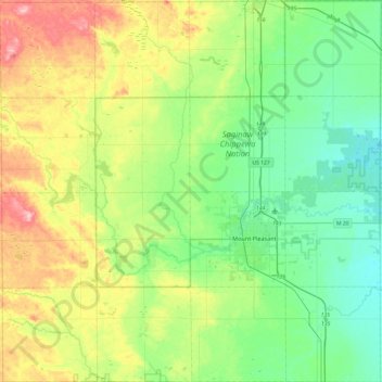
Name: Topografische Karte Isabella County, Höhe, Relief.
Ort: Isabella County, Michigan, United States of America (43.46593 -85.08881 43.81526 -84.60602)
Durchschnittliche Höhe: 261 m
Minimale Höhe: 207 m
Maximale Höhe: 380 m
Andere topografische Karten
Klicken Sie auf eine Karte, um ihre Topografie, ihre Höhe und ihr Relief anzuzeigen.
Waterford Township
United States of America > Michigan > Waterford Township
Waterford Township, Oakland County, Michigan, 2800, United States of America
Durchschnittliche Höhe: 295 m
Little Island
United States of America > Michigan
Little Island, Michigan, United States of America
Durchschnittliche Höhe: 178 m
Summit Township
United States of America > Michigan
Summit Township, Jackson County, Michigan, 49203, United States of America
Durchschnittliche Höhe: 300 m
Baraga County
United States of America > Michigan
Baraga County, Michigan, United States of America
Durchschnittliche Höhe: 378 m
Pontiac
United States of America > Michigan > Pontiac
Pontiac, Oakland County, Michigan, United States of America
Durchschnittliche Höhe: 290 m
Lost Lake Woods
United States of America > Michigan > Lost Lake Woods
Lost Lake Woods, Alcona Township, Alcona County, Michigan, United States of America
Durchschnittliche Höhe: 248 m
Saginaw County
United States of America > Michigan
Saginaw County, Michigan, United States of America
Durchschnittliche Höhe: 193 m
Ingham County
United States of America > Michigan
Ingham County, Michigan, United States of America
Durchschnittliche Höhe: 278 m
Ontonagon County
United States of America > Michigan
Ontonagon County, Michigan, United States of America
Durchschnittliche Höhe: 334 m
East Lansing
United States of America > Michigan > East Lansing > East Lansing
East Lansing, Ingham County, Michigan, United States of America
Durchschnittliche Höhe: 261 m