
Topografische Karte Bamberton Provincial Park
Interaktive Karte
Klicken Sie auf die Karte, um die Höhe anzuzeigen.
Über diese Karte
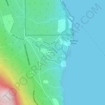
Name: Topografische Karte Bamberton Provincial Park, Höhe, Relief.
Durchschnittliche Höhe: 97 m
Minimale Höhe: 0 m
Maximale Höhe: 554 m
Andere topografische Karten
Klicken Sie auf eine Karte, um ihre Topografie, ihre Höhe und ihr Relief anzuzeigen.
Mill Bay
Canada > British Columbia > Cowichan Valley Regional District > Area A (Mill Bay / Malahat)
Mill Bay, Area A (Mill Bay / Malahat), Cowichan Valley Regional District, British Columbia, V0R 2P1, Canada
Durchschnittliche Höhe: 61 m
H500
Canada > British Columbia > Cowichan Valley Regional District > Area A (Mill Bay / Malahat)
H500, Area A (Mill Bay / Malahat), Cowichan Valley Regional District, British Columbia, V0R 2P4, Canada
Durchschnittliche Höhe: 341 m