
Topografische Karte La Fournière
Interaktive Karte
Klicken Sie auf die Karte, um die Höhe anzuzeigen.
Über diese Karte
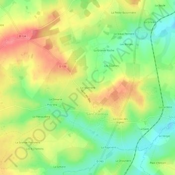
Name: Topografische Karte La Fournière, Höhe, Relief.
Durchschnittliche Höhe: 197 m
Minimale Höhe: 161 m
Maximale Höhe: 234 m
Andere topografische Karten
Klicken Sie auf eine Karte, um ihre Topografie, ihre Höhe und ihr Relief anzuzeigen.
Saint-Pardoux
France > Nouvelle-Aquitaine > Deux-Sèvres > Saint-Pardoux-Soutiers
Saint-Pardoux, Saint-Pardoux-Soutiers, Parthenay, Deux-Sèvres, Nouvelle-Aquitaine, France métropolitaine, 79310, France
Durchschnittliche Höhe: 196 m
Soutiers
France > Nouvelle-Aquitaine > Deux-Sèvres > Saint-Pardoux-Soutiers
Soutiers, Saint-Pardoux-Soutiers, Parthenay, Deux-Sèvres, Nouvelle-Aquitaine, France métropolitaine, 79310, France
Durchschnittliche Höhe: 177 m