
Spenden
Rüsten Sie sich für Ihr nächstes Abenteuer:
Als Amazon-Partner erhält diese Website eine Provision für qualifizierte Käufe, ohne zusätzliche Kosten für Sie.
Topografische Karte Portal
Klicken Sie auf die Karte, um die Höhe anzuzeigen.
Spenden
Rüsten Sie sich für Ihr nächstes Abenteuer:
Als Amazon-Partner erhält diese Website eine Provision für qualifizierte Käufe, ohne zusätzliche Kosten für Sie.
Über diese Karte
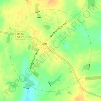
Name: Topografische Karte Portal, Höhe, Relief.
Ort: Portal, Bulloch County, Georgia, United States (32.52541 -81.94322 32.54729 -81.91741)
Durchschnittliche Höhe: 85 m
Minimale Höhe: 67 m
Maximale Höhe: 96 m
Spenden
Rüsten Sie sich für Ihr nächstes Abenteuer:
Als Amazon-Partner erhält diese Website eine Provision für qualifizierte Käufe, ohne zusätzliche Kosten für Sie.
Andere topografische Karten
Klicken Sie auf eine Karte, um ihre Topografie, ihre Höhe und ihr Relief anzuzeigen.
Statesboro
United States > Georgia > Bulloch County
According to the United States Census Bureau, the city has a total area of 13.9 square miles (35.9 km2), of which 13.5 square miles (35.0 km2) is land and 0.35 square miles (0.9 km2), or 2.60%, is water. The city is in the coastal plain region, or Low Country, of Georgia, so it is mainly flat with a few small…
Durchschnittliche Höhe: 64 m
Spenden
Rüsten Sie sich für Ihr nächstes Abenteuer:
Als Amazon-Partner erhält diese Website eine Provision für qualifizierte Käufe, ohne zusätzliche Kosten für Sie.
Statesboro
United States > Georgia > Bulloch County
According to the United States Census Bureau, the city has a total area of 13.9 square miles (35.9 km2), of which 13.5 square miles (35.0 km2) is land and 0.35 square miles (0.9 km2), or 2.60%, is water. The city is in the coastal plain region, or Low Country, of Georgia, so it is mainly flat with a few small…
Durchschnittliche Höhe: 64 m