
Topografische Karte Garvey Park
Interaktive Karte
Klicken Sie auf die Karte, um die Höhe anzuzeigen.
Über diese Karte
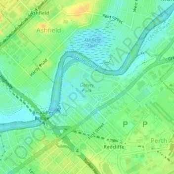
Name: Topografische Karte Garvey Park, Höhe, Relief.
Durchschnittliche Höhe: 11 m
Minimale Höhe: -1 m
Maximale Höhe: 26 m
Andere topografische Karten
Klicken Sie auf eine Karte, um ihre Topografie, ihre Höhe und ihr Relief anzuzeigen.
Cloverdale
Australia > Western Australia > City of Belmont
Cloverdale, City of Belmont, Western Australia, 6105, Australia
Durchschnittliche Höhe: 20 m
Rivervale
Australia > Western Australia > City of Belmont
Rivervale, City of Belmont, Western Australia, 6103, Australia
Durchschnittliche Höhe: 16 m
Kewdale
Australia > Western Australia > City of Belmont
Kewdale, City of Belmont, Western Australia, 6105, Australia
Durchschnittliche Höhe: 18 m
Ascot
Australia > Western Australia > City of Belmont
Ascot, City of Belmont, Western Australia, 6104, Australia
Durchschnittliche Höhe: 12 m
Belmont
Australia > Western Australia > City of Belmont
Belmont, City of Belmont, Western Australia, 6103, Australia
Durchschnittliche Höhe: 16 m
Adachi Park
Australia > Western Australia > City of Belmont
Adachi Park, Ascot, City of Belmont, Western Australia, 6104, Australia
Durchschnittliche Höhe: 11 m