
Topografische Karte Treasure Island
Interaktive Karte
Klicken Sie auf die Karte, um die Höhe anzuzeigen.
Über diese Karte
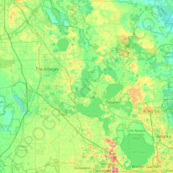
Name: Topografische Karte Treasure Island, Höhe, Relief.
Ort: Treasure Island, Lake County, Florida, USA (28.54165 -82.15758 29.18165 -81.51758)
Durchschnittliche Höhe: 25 m
Minimale Höhe: 2 m
Maximale Höhe: 95 m
Andere topografische Karten
Klicken Sie auf eine Karte, um ihre Topografie, ihre Höhe und ihr Relief anzuzeigen.
Cantonment
USA > Florida > Cantonment
Cantonment, Escambia County, Florida, 11142, USA
Durchschnittliche Höhe: 38 m
Mountain Lake Station
USA > Florida > Mountain Lake Station
Mountain Lake Station, Polk County, Florida, 33877, USA
Durchschnittliche Höhe: 47 m
Harbor Shores
USA > Florida > Harbor Shores
Harbor Shores, Lake County, Florida, 32735, USA
Durchschnittliche Höhe: 23 m
The Villages
USA > Florida > The Villages
The Villages, Lake County, Florida, USA
Durchschnittliche Höhe: 27 m
Deerfield Beach
USA > Florida > Deerfield Beach
Deerfield Beach, Broward County, Florida, USA
Durchschnittliche Höhe: 5 m
Dawson Island
USA > Florida > Jacksonville
Dawson Island, Jacksonville, Duval County, Florida, USA
Durchschnittliche Höhe: 2 m
St. Augustine
USA > Florida > St. Augustine
St. Augustine, St. Johns County, Florida, 32084, USA
Durchschnittliche Höhe: 5 m
Dry Tortugas National Park
Dry Tortugas National Park, Monroe County, Florida, USA
Durchschnittliche Höhe: 0 m