
Topografische Karte Skopelos
Interaktive Karte
Klicken Sie auf die Karte, um die Höhe anzuzeigen.
Über diese Karte
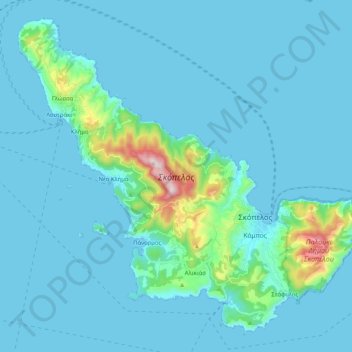
Name: Topografische Karte Skopelos, Höhe, Relief.
Durchschnittliche Höhe: 59 m
Minimale Höhe: -1 m
Maximale Höhe: 658 m
The second largest settlement is Glossa village, situated on the northwestern tip of the island, just above Loutraki harbour, with an elevation ranging from 200 to 300 m (656 to 984 ft). It is 25.4 km (15.8 mi) from Skopelos town. It is a tranquil village with traditional houses, with 993 residents.