
Topografische Karte Pine Island
Interaktive Karte
Klicken Sie auf die Karte, um die Höhe anzuzeigen.
Über diese Karte
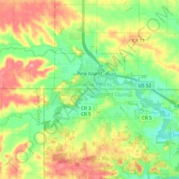
Name: Topografische Karte Pine Island, Höhe, Relief.
Ort: Pine Island, Goodhue County, Minnesota, United States (44.17309 -92.67136 44.21720 -92.54342)
Durchschnittliche Höhe: 327 m
Minimale Höhe: 291 m
Maximale Höhe: 377 m
Andere topografische Karten
Klicken Sie auf eine Karte, um ihre Topografie, ihre Höhe und ihr Relief anzuzeigen.
Red Wing
United States > Minnesota > Goodhue County
Red Wing, Goodhue County, Minnesota, United States
Durchschnittliche Höhe: 263 m
Woodbury WMA
United States > Minnesota > Goodhue County > Zumbrota
Woodbury WMA, 460th Street, Zumbrota, Minneola Township, Goodhue County, Minnesota, 55946, United States
Durchschnittliche Höhe: 341 m
Florence Township
United States > Minnesota > Goodhue County
Florence Township, Goodhue County, Minnesota, 55026, United States
Durchschnittliche Höhe: 266 m
Welch
United States > Minnesota > Goodhue County
Welch, Goodhue County, Minnesota, 55089, United States
Durchschnittliche Höhe: 277 m
Cannon Falls
United States > Minnesota > Goodhue County > Cannon Falls > Cannon Falls
Cannon Falls, Goodhue County, Minnesota, 55009, United States
Durchschnittliche Höhe: 268 m