
Topografische Karte Galena
Interaktive Karte
Klicken Sie auf die Karte, um die Höhe anzuzeigen.
Über diese Karte
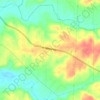
Name: Topografische Karte Galena, Höhe, Relief.
Ort: Galena, Floyd County, Indiana, United States (38.33619 -85.95879 38.36460 -85.91958)
Durchschnittliche Höhe: 232 m
Minimale Höhe: 204 m
Maximale Höhe: 266 m
Andere topografische Karten
Klicken Sie auf eine Karte, um ihre Topografie, ihre Höhe und ihr Relief anzuzeigen.
Floyds Knobs
United States > Indiana > Floyd County
Floyds Knobs, Floyd County, Indiana, 47146, United States
Durchschnittliche Höhe: 251 m
Greenville
United States > Indiana > Floyd County
Greenville, Floyd County, Indiana, 47124, United States
Durchschnittliche Höhe: 245 m
Georgetown
United States > Indiana > Floyd County
Georgetown, Floyd County, Indiana, 47122, United States
Durchschnittliche Höhe: 248 m
New Albany
United States > Indiana > Floyd County
New Albany, Floyd County, Indiana, 47150, United States
Durchschnittliche Höhe: 180 m
Silver Hills
United States > Indiana > Floyd County > New Albany
Silver Hills, New Albany, Floyd County, Indiana, 47150, United States
Durchschnittliche Höhe: 160 m
Edwardsville
United States > Indiana > Floyd County
Edwardsville, Floyd County, Indiana, United States
Durchschnittliche Höhe: 249 m