
Topografische Karte Beachville
Interaktive Karte
Klicken Sie auf die Karte, um die Höhe anzuzeigen.
Über diese Karte
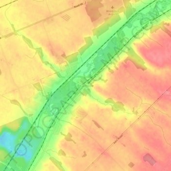
Name: Topografische Karte Beachville, Höhe, Relief.
Durchschnittliche Höhe: 303 m
Minimale Höhe: 249 m
Maximale Höhe: 333 m
Andere topografische Karten
Klicken Sie auf eine Karte, um ihre Topografie, ihre Höhe und ihr Relief anzuzeigen.
Sweaburg
Canada > Ontario > Oxford County > South-West Oxford
Sweaburg, South-West Oxford, Oxford County, Ontario, N0J 1A0, Canada
Durchschnittliche Höhe: 317 m
Mount Elgin
Canada > Ontario > Oxford County > South-West Oxford
Mount Elgin, South-West Oxford, Oxford County, Ontario, N0J 1N0, Canada
Durchschnittliche Höhe: 281 m
Salford
Canada > Ontario > Oxford County > South-West Oxford
Salford, South-West Oxford, Oxford County, Southwestern Ontario, Ontario, N5C 3J8, Canada
Durchschnittliche Höhe: 291 m
South-West Oxford
Canada > Ontario > Oxford County > South-West Oxford
South-West Oxford, Oxford County, Southwestern Ontario, Ontario, Canada
Durchschnittliche Höhe: 281 m