
Topografische Karte William Lake
Interaktive Karte
Klicken Sie auf die Karte, um die Höhe anzuzeigen.
Über diese Karte
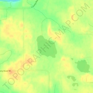
Name: Topografische Karte William Lake, Höhe, Relief.
Durchschnittliche Höhe: 400 m
Minimale Höhe: 378 m
Maximale Höhe: 413 m
Andere topografische Karten
Klicken Sie auf eine Karte, um ihre Topografie, ihre Höhe und ihr Relief anzuzeigen.
Sturgeon Lake
USA > Minnesota > Sturgeon Lake
Sturgeon Lake, Pine County, Minnesota, 55783, USA
Durchschnittliche Höhe: 325 m
Kettle River
Kettle River, Carlton County, Minnesota, 55757, USA
Durchschnittliche Höhe: 367 m
Credit River
Credit River, Savage, Scott County, Minnesota, 55378, USA
Durchschnittliche Höhe: 224 m
Maplewood State Park
Maplewood State Park, Otter Tail County, Minnesota, USA
Durchschnittliche Höhe: 429 m
Saint Croix River
Saint Croix River, Town of Eureka, Chisago County, Minnesota, 54838, USA
Durchschnittliche Höhe: 322 m
Pelican Rapids
USA > Minnesota > Pelican Rapids
Pelican Rapids, Otter Tail County, Minnesota, USA
Durchschnittliche Höhe: 405 m
Cathedral Hill Park
USA > Minnesota > Saint Paul
Cathedral Hill Park, Saint Paul, Ramsey County, Minnesota, USA
Durchschnittliche Höhe: 252 m
Birch River
Birch River, Saint Louis County, Minnesota, USA
Durchschnittliche Höhe: 452 m
Old Mill State Park
Old Mill State Park, Foldahl, Marshall County, Minnesota, USA
Durchschnittliche Höhe: 299 m
Burrows Lake
Burrows Lake, North Burrows Lake Road, Itasca County, Minnesota, USA
Durchschnittliche Höhe: 426 m
Buckshot Lake
Buckshot Lake, Portage, Cook County, Minnesota, USA
Durchschnittliche Höhe: 593 m
Smith Lake
USA > Minnesota > Smith Lake
Smith Lake, Wright County, Minnesota, USA
Durchschnittliche Höhe: 319 m
Hjalmer Lake
Hjalmer Lake, Nelson Road, Toimi, Lake County, Minnesota, USA
Durchschnittliche Höhe: 550 m
Armstrong River
Armstrong River, Saint Louis County, Minnesota, USA
Durchschnittliche Höhe: 432 m
Clearwater River
Clearwater River, Meeker County, Minnesota, 55389, USA
Durchschnittliche Höhe: 353 m
Alexandria
USA > Minnesota > Alexandria
Alexandria, Douglas County, Minnesota, 56308, USA
Durchschnittliche Höhe: 426 m
Bennett Lake
Bennett Lake, County Road C, Roseville, Ramsey County, Minnesota, 55113, USA
Durchschnittliche Höhe: 282 m
Carley State Park
Carley State Park, Wabasha County, Minnesota, USA
Durchschnittliche Höhe: 331 m
Buffalo Lake
USA > Minnesota > Buffalo Lake
Buffalo Lake, Renville County, Minnesota, USA
Durchschnittliche Höhe: 325 m
Stewart River
Stewart River, Lake County, Minnesota, 55616, USA
Durchschnittliche Höhe: 335 m
Wenonah
USA > Minnesota > Minneapolis
Wenonah, Minneapolis, Hennepin County, Minnesota, USA
Durchschnittliche Höhe: 255 m
Gervais Lake
USA > Minnesota > Little Canada
Gervais Lake, Carla Lane, Little Canada, Ramsey County, Minnesota, 55109, USA
Durchschnittliche Höhe: 271 m
Island Lake
USA > Minnesota > Island Lake
Island Lake, Beltrami County, Minnesota, USA
Durchschnittliche Höhe: 408 m
Johnson River
Johnson River, Saint Louis County, Minnesota, USA
Durchschnittliche Höhe: 382 m
Hiawatha
USA > Minnesota > Minneapolis
Hiawatha, Minneapolis, Hennepin County, Minnesota, USA
Durchschnittliche Höhe: 249 m
Black Duck River
Black Duck River, Saint Louis County, Minnesota, USA
Durchschnittliche Höhe: 422 m
Elbow River
Elbow River, Saint Louis County, Minnesota, USA
Durchschnittliche Höhe: 429 m
Little Mississippi River
Little Mississippi River, Clearwater County, Minnesota, USA
Durchschnittliche Höhe: 439 m
Green Water Lake
Green Water Lake, County Highway 35, Pine Point, Becker County, Minnesota, 56575, USA
Durchschnittliche Höhe: 481 m
Redhorse Creek
Redhorse Creek, Pine County, Minnesota, USA
Durchschnittliche Höhe: 274 m
Stonemill Farms South Park
Stonemill Farms South Park, Woodbury, Washington County, Minnesota, USA
Durchschnittliche Höhe: 302 m
Cottonwood River
Cottonwood River, Brown County, Minnesota, 231, USA
Durchschnittliche Höhe: 280 m
Glacial Lakes State Park
Glacial Lakes State Park, Pope County, Minnesota, USA
Durchschnittliche Höhe: 382 m