
Topografische Karte Kettle River
Interaktive Karte
Klicken Sie auf die Karte, um die Höhe anzuzeigen.
Über diese Karte
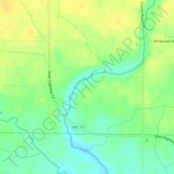
Name: Topografische Karte Kettle River, Höhe, Relief.
Ort: Kettle River, Carlton County, Minnesota, 55757, USA (46.51087 -92.90384 46.51552 -92.89590)
Durchschnittliche Höhe: 367 m
Minimale Höhe: 354 m
Maximale Höhe: 379 m
Andere topografische Karten
Klicken Sie auf eine Karte, um ihre Topografie, ihre Höhe und ihr Relief anzuzeigen.
Alexandria
USA > Minnesota > Alexandria
Alexandria, Douglas County, Minnesota, 56308, USA
Durchschnittliche Höhe: 426 m
Thermal Lake
Thermal Lake, Snowbank Trail, Lake County, Minnesota, USA
Durchschnittliche Höhe: 429 m
Prospect Park - East River Road
USA > Minnesota > Minneapolis
Prospect Park - East River Road, Minneapolis, Hennepin County, Minnesota, USA
Durchschnittliche Höhe: 260 m
Lake of the Woods County
Lake of the Woods County, Minnesota, USA
Durchschnittliche Höhe: 343 m