
Topografische Karte Ekurhuleni Ward 31
Interaktive Karte
Klicken Sie auf die Karte, um die Höhe anzuzeigen.
Über diese Karte
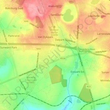
Name: Topografische Karte Ekurhuleni Ward 31, Höhe, Relief.
Durchschnittliche Höhe: 1.617 m
Minimale Höhe: 1.566 m
Maximale Höhe: 1.667 m
Andere topografische Karten
Klicken Sie auf eine Karte, um ihre Topografie, ihre Höhe und ihr Relief anzuzeigen.
Braamfontein Spruit
RSA > Gauteng > Johannesburg
Braamfontein Spruit, Johannesburg, City of Johannesburg Metropolitan Municipality, Gauteng, 2001, RSA
Durchschnittliche Höhe: 1.672 m
Roodeplaat Dam
Roodeplaat Dam, Dwars Road, Tshwane Ward 99, Pretoria, City of Tshwane Metropolitan Municipality, Gauteng, 0035, RSA
Durchschnittliche Höhe: 1.240 m
Roodepoort
RSA > Gauteng > Roodepoort
Roodepoort, City of Johannesburg Metropolitan Municipality, Gauteng, 1734, RSA
Durchschnittliche Höhe: 1.612 m
Tshwane Ward 85
Tshwane Ward 85, Pretoria, City of Tshwane Metropolitan Municipality, Gauteng, RSA
Durchschnittliche Höhe: 1.391 m
Johannesburg Ward 97
RSA > Gauteng > Roodepoort
Johannesburg Ward 97, Roodepoort, City of Johannesburg Metropolitan Municipality, Gauteng, 2040, RSA
Durchschnittliche Höhe: 1.582 m
Ekurhuleni Ward 75
Ekurhuleni Ward 75, Springs, City of Ekurhuleni Metropolitan Municipality, Gauteng, RSA
Durchschnittliche Höhe: 1.607 m
Tshwane Ward 77
Tshwane Ward 77, Pretoria, City of Tshwane Metropolitan Municipality, Gauteng, RSA
Durchschnittliche Höhe: 1.502 m
Johannesburg Ward 101
Johannesburg Ward 101, Randburg, City of Johannesburg Metropolitan Municipality, Gauteng, 2188, RSA
Durchschnittliche Höhe: 1.523 m
Ekurhuleni Ward 28
Ekurhuleni Ward 28, Benoni, City of Ekurhuleni Metropolitan Municipality, Gauteng, RSA
Durchschnittliche Höhe: 1.651 m
Johannesburg Ward 64
RSA > Gauteng > Johannesburg
Johannesburg Ward 64, Johannesburg, City of Johannesburg Metropolitan Municipality, Gauteng, 2001, RSA
Durchschnittliche Höhe: 1.758 m
Johannesburg Ward 74
Johannesburg Ward 74, Sandton, City of Johannesburg Metropolitan Municipality, Gauteng, RSA
Durchschnittliche Höhe: 1.638 m
Tshwane Ward 46
Tshwane Ward 46, Pretoria, City of Tshwane Metropolitan Municipality, Gauteng, RSA
Durchschnittliche Höhe: 1.396 m