
Spenden
Rüsten Sie sich für Ihr nächstes Abenteuer:
Als Amazon-Partner erhält diese Website eine Provision für qualifizierte Käufe, ohne zusätzliche Kosten für Sie.
Topografische Karte Gandhinagar
Klicken Sie auf die Karte, um die Höhe anzuzeigen.
Spenden
Rüsten Sie sich für Ihr nächstes Abenteuer:
Als Amazon-Partner erhält diese Website eine Provision für qualifizierte Käufe, ohne zusätzliche Kosten für Sie.
Gandhinagar
Gandhinagar has an average elevation of 81 metres (266 feet). The city sits on the banks of the Sabarmati River, in north-central-east Gujarat. The 20,543 km2 area around Gandhinagar is defined by Gujarat capital territory. Gandhinagar spans an area of 326 km2 (126 sq mi). The river frequently dries up in the summer, leaving only a small stream of water. Gandhinagar is India's tree capital With 54% green cover on its land area.
Spenden
Rüsten Sie sich für Ihr nächstes Abenteuer:
Als Amazon-Partner erhält diese Website eine Provision für qualifizierte Käufe, ohne zusätzliche Kosten für Sie.
Über diese Karte
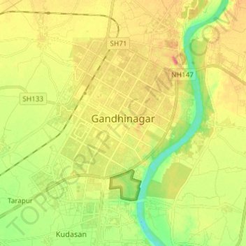
Name: Topografische Karte Gandhinagar, Höhe, Relief.
Ort: Gandhinagar, Gandhinagar Taluka, Gandhinagar, Gujarat, India (23.16497 72.60257 23.27701 72.68906)
Durchschnittliche Höhe: 75 m
Minimale Höhe: 45 m
Maximale Höhe: 104 m
Spenden
Rüsten Sie sich für Ihr nächstes Abenteuer:
Als Amazon-Partner erhält diese Website eine Provision für qualifizierte Käufe, ohne zusätzliche Kosten für Sie.
Andere topografische Karten
Klicken Sie auf eine Karte, um ihre Topografie, ihre Höhe und ihr Relief anzuzeigen.
Gandhinagar
India > Gujarat > Gandhinagar Taluka > Gandhinagar
Gandhinagar has an average elevation of 81 metres (266 feet). The city sits on the banks of the Sabarmati River, in north-central-east Gujarat. The 20,543 km2 area around Gandhinagar is defined by Gujarat capital territory. It spans an area of 205 km2 (79 sq mi). The river frequently dries up in the summer,…
Durchschnittliche Höhe: 76 m
Adalaj
India > Gujarat > Gandhinagar Taluka
Adalaj is located at 23°10′N 72°35′E / 23.17°N 72.58°E / 23.17; 72.58. It has an average elevation of 66 metres (217 ft). According to the Bureau of Indian Standards, the town falls under seismic zone 3, in a scale of 2 to 5 (in order of increasing vulnerability to earthquakes).
Durchschnittliche Höhe: 66 m