
Topografische Karte Montelupo Fiorentino
Interaktive Karte
Klicken Sie auf die Karte, um die Höhe anzuzeigen.
Über diese Karte
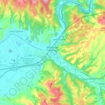
Name: Topografische Karte Montelupo Fiorentino, Höhe, Relief.
Durchschnittliche Höhe: 95 m
Minimale Höhe: 14 m
Maximale Höhe: 272 m
Andere topografische Karten
Klicken Sie auf eine Karte, um ihre Topografie, ihre Höhe und ihr Relief anzuzeigen.
Gambassi
Italy > Tuscany > Metropolitan City of Florence > Reggello
Gambassi, Reggello, Metropolitan City of Florence, Tuscany, 50064, Italy
Durchschnittliche Höhe: 175 m