Geolokalisieren

Topografische Karte Ashley

Klicken Sie auf die Karte, um die Höhe anzuzeigen.

Über diese Karte

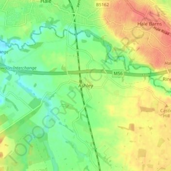
Name: Topografische Karte Ashley, Höhe, Relief.

Ort: Ashley, Cheshire East, England, WA15 0QR, United Kingdom (53.33472 -2.35942 53.37472 -2.31942)

Durchschnittliche Höhe: 44 m

Minimale Höhe: 20 m

Maximale Höhe: 71 m

Andere topografische Karten

Klicken Sie auf eine Karte, um ihre Topografie, ihre Höhe und ihr Relief anzuzeigen.

Audlem

United Kingdom > England > Cheshire East

Durchschnittliche Höhe: 72 m

Wilmslow

United Kingdom > England > Cheshire East

Durchschnittliche Höhe: 81 m

Nether Alderley

United Kingdom > England > Cheshire East

Durchschnittliche Höhe: 98 m

Norbury

United Kingdom > England > Cheshire East

Durchschnittliche Höhe: 82 m

Smallwood

United Kingdom > England > Cheshire East

Durchschnittliche Höhe: 86 m

Alderley Edge

United Kingdom > England > Cheshire East > Alderley Edge

Alderley Edge is 6 miles (10 km) northwest of Macclesfield and 12 miles (19 km) south of Manchester, at the base of a steep and thickly wooded sandstone escarpment, Alderley Edge, which is the area's chief topographical feature and overlooks the Cheshire Plain.

Durchschnittliche Höhe: 91 m

Nantwich

United Kingdom > England > Cheshire East

Durchschnittliche Höhe: 45 m

Knutsford

United Kingdom > England > Cheshire East

Durchschnittliche Höhe: 58 m

Walgherton

United Kingdom > England > Cheshire East > Wybunbury > Walgherton

Durchschnittliche Höhe: 63 m

Disley

United Kingdom > England > Cheshire East

Durchschnittliche Höhe: 229 m

Chorley

United Kingdom > England > Cheshire East > Chorley

Durchschnittliche Höhe: 73 m

Church Minshull

United Kingdom > England > Cheshire East

Durchschnittliche Höhe: 45 m

Cholmondeston

United Kingdom > England > Cheshire East

The civil parish has a total area of 1,749 acres (708 ha).[17] The terrain is predominantly flat, with an average elevation of around 50 metres. A trig point is located at SJ631567, at an elevation of 55 metres. Crowton Brook runs north–south through the civil parish and Bankside Brook forms part of the…

Durchschnittliche Höhe: 48 m

Rüsten Sie sich für Ihr nächstes Abenteuer:

📷Kamera Schutz Hülle - Wasserdichte Hülle für Outdoor Kameras
💼Reise Gürteltasche - Kleine Tasche für Karten & Handy
🌙Schlafmaske Comfort - Für erholsamen Schlaf im Zelt
📍GPS Wanderuhr - Smartwatch mit Navigation & Kartenfeatures
🧵Paracord-Schnüre - Vielseitige Seile für Reparaturen und Lagerbau

Als Amazon-Partner erhält diese Website eine Provision für qualifizierte Käufe, ohne zusätzliche Kosten für Sie.