
Topografische Karte Pray Lake
Interaktive Karte
Klicken Sie auf die Karte, um die Höhe anzuzeigen.
Über diese Karte
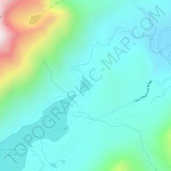
Name: Topografische Karte Pray Lake, Höhe, Relief.
Ort: Pray Lake, Glacier County, Montana, United States (48.48916 -113.36698 48.49154 -113.36420)
Durchschnittliche Höhe: 1.717 m
Minimale Höhe: 1.497 m
Maximale Höhe: 2.569 m
Andere topografische Karten
Klicken Sie auf eine Karte, um ihre Topografie, ihre Höhe und ihr Relief anzuzeigen.
Basin Mountain
United States > Montana > Glacier County
Basin Mountain, Glacier County, Montana, United States
Durchschnittliche Höhe: 2.075 m
Cut Bank
United States > Montana > Glacier County
Cut Bank, Glacier County, Montana, United States
Durchschnittliche Höhe: 1.147 m