
Topografische Karte Forest City
Interaktive Karte
Klicken Sie auf die Karte, um die Höhe anzuzeigen.
Über diese Karte
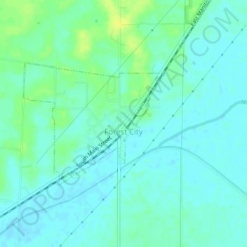
Name: Topografische Karte Forest City, Höhe, Relief.
Ort: Forest City, Mason County, Illinois, United States (40.36418 -89.84197 40.37756 -89.82163)
Durchschnittliche Höhe: 153 m
Minimale Höhe: 147 m
Maximale Höhe: 166 m
Andere topografische Karten
Klicken Sie auf eine Karte, um ihre Topografie, ihre Höhe und ihr Relief anzuzeigen.
Goofy Ridge
United States > Illinois > Mason County
Goofy Ridge, Mason County, Illinois, 61567, United States
Durchschnittliche Höhe: 147 m
Manito
United States > Illinois > Mason County
Manito, Mason County, Illinois, United States
Durchschnittliche Höhe: 153 m
Wolf Lake
United States > Illinois > Mason County
Wolf Lake, Mason County, Illinois, 62627, United States
Durchschnittliche Höhe: 141 m