
Topografische Karte Lake Junaluska
Interaktive Karte
Klicken Sie auf die Karte, um die Höhe anzuzeigen.
Über diese Karte
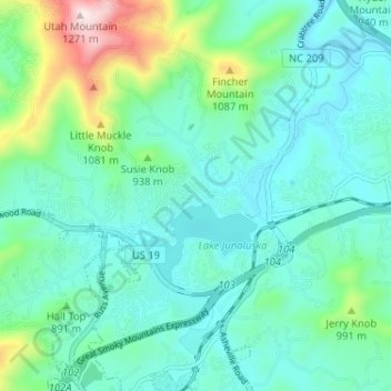
Name: Topografische Karte Lake Junaluska, Höhe, Relief.
Durchschnittliche Höhe: 862 m
Minimale Höhe: 757 m
Maximale Höhe: 1.269 m
Andere topografische Karten
Klicken Sie auf eine Karte, um ihre Topografie, ihre Höhe und ihr Relief anzuzeigen.
Waynesville
United States > North Carolina > Haywood County
Waynesville, Haywood County, North Carolina, 28786, United States
Durchschnittliche Höhe: 921 m
Mount Lyn Lowry
United States > North Carolina > Haywood County
Mount Lyn Lowry, Haywood County, North Carolina, United States
Durchschnittliche Höhe: 1.586 m
Little Bird Falls
United States > North Carolina > Haywood County
Little Bird Falls, Haywood County, North Carolina, United States
Durchschnittliche Höhe: 1.347 m
Lake Logan
United States > North Carolina > Haywood County > Sunburst
Lake Logan, Sunburst, Haywood County, North Carolina, United States
Durchschnittliche Höhe: 1.061 m
Sugartree Licks
United States > North Carolina > Haywood County
Sugartree Licks, Haywood County, North Carolina, United States
Durchschnittliche Höhe: 1.505 m
Hazelwood
United States > North Carolina > Haywood County > Waynesville
Hazelwood, Waynesville, Haywood County, North Carolina, 28786, United States
Durchschnittliche Höhe: 888 m
Clyde
United States > North Carolina > Haywood County
Clyde, Haywood County, North Carolina, United States
Durchschnittliche Höhe: 802 m
The Glades
United States > North Carolina > Haywood County
The Glades, Haywood County, North Carolina, United States
Durchschnittliche Höhe: 1.164 m
Maggie Valley
United States > North Carolina > Haywood County
Maggie Valley, Haywood County, North Carolina, United States
Durchschnittliche Höhe: 1.247 m
Panther Creek
United States > North Carolina > Haywood County > Panther Creek
Panther Creek, Haywood County, North Carolina, United States
Durchschnittliche Höhe: 873 m