
Topografische Karte Amanvillers
Interaktive Karte
Klicken Sie auf die Karte, um die Höhe anzuzeigen.
Über diese Karte
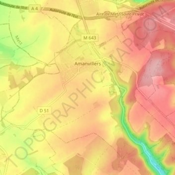
Name: Topografische Karte Amanvillers, Höhe, Relief.
Durchschnittliche Höhe: 322 m
Minimale Höhe: 233 m
Maximale Höhe: 375 m
Le village d'Amanvillers est situé au débouché de la Vallée de Montvaux, à 15 km environ au nord-ouest de Metz, à une altitude moyenne de 320 m. C'est l'une des entrées du Pays Haut. Amanvillers a comme annexes les fermes de Champenois, de Montigny la Grange et de Saint-Vincent.
Andere topografische Karten
Klicken Sie auf eine Karte, um ihre Topografie, ihre Höhe und ihr Relief anzuzeigen.
57280
France > Grand Est > Moselle > Hauconcourt
57280, Hauconcourt, Metz, Moselle, Grand Est, France métropolitaine, France
Durchschnittliche Höhe: 164 m
Givrycourt
Givrycourt, Sarrebourg-Château-Salins, Moselle, Grand Est, France métropolitaine, 57670, France
Durchschnittliche Höhe: 231 m
Seingbouse
Seingbouse, Forbach-Boulay-Moselle, Moselle, Grand Est, France métropolitaine, 57455, France
Durchschnittliche Höhe: 293 m
Mondelange
Mondelange, Thionville, Moselle, Grand Est, France métropolitaine, 57300, France
Durchschnittliche Höhe: 162 m
Thionville
Thionville, Moselle, Grand Est, France métropolitaine, 57100, France
Durchschnittliche Höhe: 190 m
Mainvillers
Mainvillers, Forbach-Boulay-Moselle, Moselle, Grand Est, France métropolitaine, 57380, France
Durchschnittliche Höhe: 270 m
Loutzviller
Loutzviller, Sarreguemines, Moselle, Grand Est, France métropolitaine, 57720, France
Durchschnittliche Höhe: 308 m
Neufmoulins
Neufmoulins, Sarrebourg-Château-Salins, Moselle, Grand Est, France métropolitaine, 57830, France
Durchschnittliche Höhe: 290 m
Laudrefang
Laudrefang, Forbach-Boulay-Moselle, Moselle, Grand Est, France métropolitaine, 57385, France
Durchschnittliche Höhe: 352 m
Servigny-lès-Raville
Servigny-lès-Raville, Metz, Moselle, Grand Est, France métropolitaine, 57530, France
Durchschnittliche Höhe: 278 m
Philippsbourg
Philippsbourg, Sarreguemines, Moselle, Grand Est, France métropolitaine, 57230, France
Durchschnittliche Höhe: 284 m
Pierrevillers
Pierrevillers, Metz, Moselle, Grand Est, France métropolitaine, 57120, France
Durchschnittliche Höhe: 270 m
Momerstroff
Momerstroff, Forbach-Boulay-Moselle, Moselle, Grand Est, France métropolitaine, 57220, France
Durchschnittliche Höhe: 340 m
Haraucourt-sur-Seille
Haraucourt-sur-Seille, Sarrebourg-Château-Salins, Moselle, Grand Est, France métropolitaine, 57630, France
Durchschnittliche Höhe: 256 m
Corny-sur-Moselle
Corny-sur-Moselle, Metz, Moselle, Grand Est, France métropolitaine, 57680, France
Durchschnittliche Höhe: 238 m
57420
France > Grand Est > Moselle > Pommérieux
57420, Pommérieux, Metz, Moselle, Grand Est, France métropolitaine, France
Durchschnittliche Höhe: 197 m
Silvange
France > Grand Est > Moselle > Marange-Silvange
Silvange, Marange-Silvange, Metz, Moselle, Grand Est, France métropolitaine, 57535, France
Durchschnittliche Höhe: 198 m
Haselbourg
Haselbourg, Sarrebourg-Château-Salins, Moselle, Grand Est, France métropolitaine, 57850, France
Durchschnittliche Höhe: 347 m
Sturzelbronn
Sturzelbronn, Sarreguemines, Moselle, Grand Est, France métropolitaine, 57230, France
Durchschnittliche Höhe: 304 m
Hultehouse
Hultehouse, Sarrebourg-Château-Salins, Moselle, Grand Est, France métropolitaine, 57820, France
Durchschnittliche Höhe: 359 m
Grande Babylonne
France > Grand Est > Moselle > Herny
Grande Babylonne, Herny, Forbach-Boulay-Moselle, Moselle, Grand Est, France métropolitaine, 57580, France
Durchschnittliche Höhe: 256 m
Puttelange-aux-Lacs
Puttelange-aux-Lacs, Sarreguemines, Moselle, Grand Est, France métropolitaine, 57510, France
Durchschnittliche Höhe: 243 m
Gosselming
Gosselming, Sarrebourg-Château-Salins, Moselle, Grand Est, France métropolitaine, 57930, France
Durchschnittliche Höhe: 263 m
Bambiderstroff
Bambiderstroff, Forbach-Boulay-Moselle, Moselle, Grand Est, France métropolitaine, 57690, France
Durchschnittliche Höhe: 351 m
Aboncourt-sur-Seille
Aboncourt-sur-Seille, Sarrebourg-Château-Salins, Moselle, Grand Est, France métropolitaine, 57590, France
Durchschnittliche Höhe: 218 m