
Topografische Karte Village of Nissequogue
Interaktive Karte
Klicken Sie auf die Karte, um die Höhe anzuzeigen.
Über diese Karte
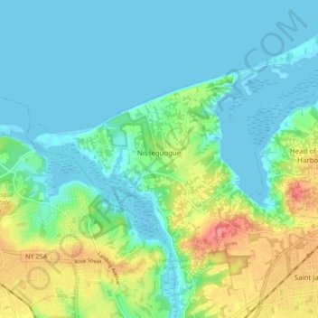
Name: Topografische Karte Village of Nissequogue, Höhe, Relief.
Durchschnittliche Höhe: 19 m
Minimale Höhe: -1 m
Maximale Höhe: 69 m
Andere topografische Karten
Klicken Sie auf eine Karte, um ihre Topografie, ihre Höhe und ihr Relief anzuzeigen.
Hauppauge
United States > New York > Suffolk County > Town of Smithtown
Hauppauge, Town of Smithtown, Suffolk County, New York, 11788, United States
Durchschnittliche Höhe: 28 m
Saint James
United States > New York > Suffolk County > Town of Smithtown
Saint James, Town of Smithtown, Suffolk County, New York, 11780, United States
Durchschnittliche Höhe: 39 m
East Hauppauge
United States > New York > Suffolk County > Town of Smithtown > Nesconset > East Hauppauge
East Hauppauge, Nesconset, Town of Smithtown, Suffolk County, New York, 11767, United States
Durchschnittliche Höhe: 28 m
Sunken Meadow State Park
United States > New York > Suffolk County > Town of Smithtown > Kings Park
Sunken Meadow State Park, Kings Park, Town of Smithtown, Suffolk County, New York, United States
Durchschnittliche Höhe: 27 m
Nesconset
United States > New York > Suffolk County > Town of Smithtown
Nesconset, Town of Smithtown, Suffolk County, New York, 11767, United States
Durchschnittliche Höhe: 31 m