
Spenden
Rüsten Sie sich für Ihr nächstes Abenteuer:
Als Amazon-Partner erhält diese Website eine Provision für qualifizierte Käufe, ohne zusätzliche Kosten für Sie.
Topografische Karte Kotagiri
Klicken Sie auf die Karte, um die Höhe anzuzeigen.
Spenden
Rüsten Sie sich für Ihr nächstes Abenteuer:
Als Amazon-Partner erhält diese Website eine Provision für qualifizierte Käufe, ohne zusätzliche Kosten für Sie.
Kotagiri
Kotagiri is a Hill town and a taluk in The Nilgiris District in the Indian state of Tamil Nadu. The name 'Kota-giri' itself means 'mountain of the Kotas'. The town has developed around numerous knolls and valleys. It is one of the largest hill station in the Nilgiri Mountains. Located at an average elevation of 1,950 m (6,400 ft), Kotagiri is quietly tucked away in the Nilgiris and used to be one of the summer resort of Madras Presidency. The town was discovered in the year 1819 by John Sullivan when he came to a village called Dhimbatty to the North of Kotagiri. Situated at an elevation of about 6,400 feet, Kotagiri enjoys the third coldest climate next to Ooty and Kodaikanal in South India.
Spenden
Rüsten Sie sich für Ihr nächstes Abenteuer:
Als Amazon-Partner erhält diese Website eine Provision für qualifizierte Käufe, ohne zusätzliche Kosten für Sie.
Über diese Karte
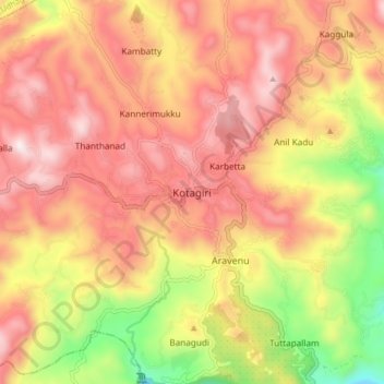
Name: Topografische Karte Kotagiri, Höhe, Relief.
Ort: Kotagiri, Nilgiris, Tamil Nadu, 643217, India (11.38304 76.82582 11.46304 76.90582)
Durchschnittliche Höhe: 1.781 m
Minimale Höhe: 1.290 m
Maximale Höhe: 2.125 m
Spenden
Rüsten Sie sich für Ihr nächstes Abenteuer:
Als Amazon-Partner erhält diese Website eine Provision für qualifizierte Käufe, ohne zusätzliche Kosten für Sie.
Andere topografische Karten
Klicken Sie auf eine Karte, um ihre Topografie, ihre Höhe und ihr Relief anzuzeigen.
Longwood Shola Reserve Forest
India > Tamil Nadu > Kotagiri > Karbetta
Durchschnittliche Höhe: 1.905 m
Longwood Shola Reserve Forest
India > Tamil Nadu > Kotagiri > Karbetta
Durchschnittliche Höhe: 1.905 m