
Topografische Karte La Mancellière-sur-Vire
Interaktive Karte
Klicken Sie auf die Karte, um die Höhe anzuzeigen.
Über diese Karte
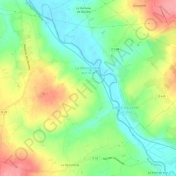
Name: Topografische Karte La Mancellière-sur-Vire, Höhe, Relief.
Durchschnittliche Höhe: 56 m
Minimale Höhe: 14 m
Maximale Höhe: 114 m
Andere topografische Karten
Klicken Sie auf eine Karte, um ihre Topografie, ihre Höhe und ihr Relief anzuzeigen.
La Mabilière
France > Normandie > Manche > Bourgvallées > Saint-Samson-de-Bonfossé
La Mabilière, Saint-Samson-de-Bonfossé, Bourgvallées, Saint-Lô, Manche, Normandie, France métropolitaine, 50750, France
Durchschnittliche Höhe: 93 m
Saint-Romphaire
France > Normandie > Manche > Bourgvallées > Saint-Romphaire
Saint-Romphaire, Bourgvallées, Saint-Lô, Manche, Normandie, France métropolitaine, 50750, France
Durchschnittliche Höhe: 99 m
Village de la Pasquerie
France > Normandie > Manche > Bourgvallées > Saint-Samson-de-Bonfossé
Village de la Pasquerie, Saint-Samson-de-Bonfossé, Bourgvallées, Saint-Lô, Manche, Normandie, France métropolitaine, 50750, France
Durchschnittliche Höhe: 104 m
Saint-Samson-de-Bonfossé
France > Normandie > Manche > Bourgvallées
Saint-Samson-de-Bonfossé, Bourgvallées, Saint-Lô, Manche, Normandie, France métropolitaine, 50750, France
Durchschnittliche Höhe: 95 m
Soulles
France > Normandie > Manche > Bourgvallées
Soulles, Bourgvallées, Saint-Lô, Manche, Normandie, France métropolitaine, 50750, France
Durchschnittliche Höhe: 121 m