
Topografische Karte Gloversville
Interaktive Karte
Klicken Sie auf die Karte, um die Höhe anzuzeigen.
Gloversville
The city sits in the foothills of the Adirondack Mountains and therefore is within a climatic transition zone. Gloversville experiences the warmer summer temperatures common throughout the Capital Region's Hudson and Mohawk Valleys while experiencing generally more copious precipitation throughout the year than the Capital Region. This manifests in commonplace rolling thunderstorms throughout the summer months and snowfall amounts more akin to the lake-pocked higher elevations of the Adirondacks in the winter months.
Über diese Karte
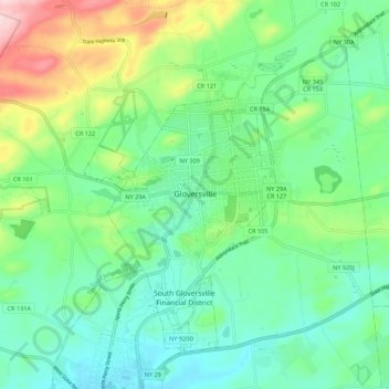
Name: Topografische Karte Gloversville, Höhe, Relief.
Ort: Gloversville, Fulton County, New York, 12078, United States (43.01281 -74.38369 43.09281 -74.30369)
Durchschnittliche Höhe: 275 m
Minimale Höhe: 202 m
Maximale Höhe: 469 m