
Topografische Karte Municipal Unit of Kamatero
Interaktive Karte
Klicken Sie auf die Karte, um die Höhe anzuzeigen.
Über diese Karte
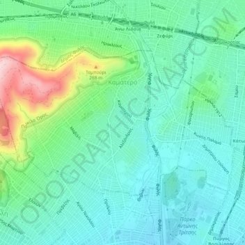
Name: Topografische Karte Municipal Unit of Kamatero, Höhe, Relief.
Durchschnittliche Höhe: 153 m
Minimale Höhe: 84 m
Maximale Höhe: 365 m
Andere topografische Karten
Klicken Sie auf eine Karte, um ihre Topografie, ihre Höhe und ihr Relief anzuzeigen.
Peristeri
Greece > Attica > Regional Unit of West Athens
Peristeri, Municipality of Peristeri, Regional Unit of West Athens, Attica, 121 34, Greece
Durchschnittliche Höhe: 223 m
Municipality of Aigaleo
Greece > Attica > Regional Unit of West Athens
Municipality of Aigaleo, Regional Unit of West Athens, Attica, Greece
Durchschnittliche Höhe: 46 m
Municipality of Petroupoli
Greece > Attica > Regional Unit of West Athens
Municipality of Petroupoli, Regional Unit of West Athens, Attica, 132 31, Greece
Durchschnittliche Höhe: 222 m
Municipality of Peristeri
Greece > Attica > Regional Unit of West Athens
Municipality of Peristeri, Regional Unit of West Athens, Attica, Greece
Durchschnittliche Höhe: 80 m