
Spenden
Rüsten Sie sich für Ihr nächstes Abenteuer:
Als Amazon-Partner erhält diese Website eine Provision für qualifizierte Käufe, ohne zusätzliche Kosten für Sie.
Topografische Karte Otay Mesa
Klicken Sie auf die Karte, um die Höhe anzuzeigen.
Spenden
Rüsten Sie sich für Ihr nächstes Abenteuer:
Als Amazon-Partner erhält diese Website eine Provision für qualifizierte Käufe, ohne zusätzliche Kosten für Sie.
Über diese Karte
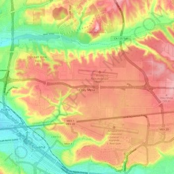
Name: Topografische Karte Otay Mesa, Höhe, Relief.
Durchschnittliche Höhe: 112 m
Minimale Höhe: 12 m
Maximale Höhe: 199 m
Spenden
Rüsten Sie sich für Ihr nächstes Abenteuer:
Als Amazon-Partner erhält diese Website eine Provision für qualifizierte Käufe, ohne zusätzliche Kosten für Sie.
Andere topografische Karten
Klicken Sie auf eine Karte, um ihre Topografie, ihre Höhe und ihr Relief anzuzeigen.
San Diego
United States > California > San Diego County > San Diego
The climate in San Diego, like most of Southern California, often varies significantly over short geographical distances, resulting in microclimates. In San Diego, this is mostly because of the city's topography (the Bay, and the numerous hills, mountains, and canyons). Frequently, particularly during the "May…
Durchschnittliche Höhe: 57 m
San Diego River
United States > California > San Diego County > San Diego
Durchschnittliche Höhe: 133 m
Spenden
Rüsten Sie sich für Ihr nächstes Abenteuer:
Als Amazon-Partner erhält diese Website eine Provision für qualifizierte Käufe, ohne zusätzliche Kosten für Sie.
Rancho Peñasquitos
United States > California > San Diego County > San Diego
The highest point in the community is Black Mountain, which rises to an elevation of 1,500 feet (460 m).
Durchschnittliche Höhe: 157 m
Lake Murray Reservoir
United States > California > San Diego County > San Diego > San Carlos
Durchschnittliche Höhe: 178 m
Torrey Pines State Natural Reserve
United States > California > San Diego County > San Diego
Durchschnittliche Höhe: 37 m
La Jolla Shores Beach
United States > California > San Diego County > San Diego
Durchschnittliche Höhe: 39 m
Spenden
Rüsten Sie sich für Ihr nächstes Abenteuer:
Als Amazon-Partner erhält diese Website eine Provision für qualifizierte Käufe, ohne zusätzliche Kosten für Sie.
Carmel Mountain
United States > California > San Diego County > San Diego
Durchschnittliche Höhe: 75 m
La Jolla
United States > California > San Diego County > San Diego > La Jolla
Durchschnittliche Höhe: 37 m
Spenden
Rüsten Sie sich für Ihr nächstes Abenteuer:
Als Amazon-Partner erhält diese Website eine Provision für qualifizierte Käufe, ohne zusätzliche Kosten für Sie.
Sorrento Valley
United States > California > San Diego County > San Diego
Durchschnittliche Höhe: 88 m
Sorrento Valley
United States > California > San Diego County > San Diego
Durchschnittliche Höhe: 88 m
Spenden
Rüsten Sie sich für Ihr nächstes Abenteuer:
Als Amazon-Partner erhält diese Website eine Provision für qualifizierte Käufe, ohne zusätzliche Kosten für Sie.