
Topografische Karte Village of Lattingtown
Interaktive Karte
Klicken Sie auf die Karte, um die Höhe anzuzeigen.
Über diese Karte
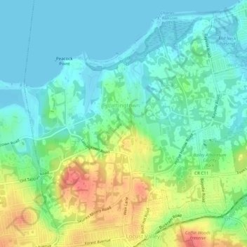
Name: Topografische Karte Village of Lattingtown, Höhe, Relief.
Durchschnittliche Höhe: 20 m
Minimale Höhe: -1 m
Maximale Höhe: 62 m
Andere topografische Karten
Klicken Sie auf eine Karte, um ihre Topografie, ihre Höhe und ihr Relief anzuzeigen.
Village of Kings Point
États-Unis d'Amérique > New York > Nassau County
Village of Kings Point, Town of North Hempstead, Nassau County, New York, 11024, États-Unis d'Amérique
Durchschnittliche Höhe: 9 m
Village of Island Park
États-Unis d'Amérique > New York > Nassau County
Village of Island Park, Town of Hempstead, Nassau County, New York, 11558, États-Unis d'Amérique
Durchschnittliche Höhe: 1 m
Village of Lynbrook
États-Unis d'Amérique > New York > Nassau County
Village of Lynbrook, Town of Hempstead, Nassau County, New York, 11563, États-Unis d'Amérique
Durchschnittliche Höhe: 8 m
Village of Mineola
États-Unis d'Amérique > New York > Nassau County
Village of Mineola, Town of North Hempstead, Nassau County, New York, 11501, États-Unis d'Amérique
Durchschnittliche Höhe: 35 m
Glen Head
États-Unis d'Amérique > New York > Nassau County
Glen Head, Town of Oyster Bay, Nassau County, New York, États-Unis d'Amérique
Durchschnittliche Höhe: 40 m
Village of Westbury
États-Unis d'Amérique > New York > Nassau County
Village of Westbury, Town of North Hempstead, Nassau County, New York, États-Unis d'Amérique
Durchschnittliche Höhe: 39 m
Village of Rockville Centre
États-Unis d'Amérique > New York > Nassau County
Village of Rockville Centre, Town of Hempstead, Nassau County, New York, 11570, États-Unis d'Amérique
Durchschnittliche Höhe: 11 m