
Topografische Karte Argostoli
Interaktive Karte
Klicken Sie auf die Karte, um die Höhe anzuzeigen.
Über diese Karte
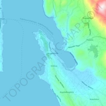
Name: Topografische Karte Argostoli, Höhe, Relief.
Durchschnittliche Höhe: 79 m
Minimale Höhe: -1 m
Maximale Höhe: 844 m
Andere topografische Karten
Klicken Sie auf eine Karte, um ihre Topografie, ihre Höhe und ihr Relief anzuzeigen.
Kefalonia
Greece > Peloponnese, Western Greece and the Ionian > Kefallonia Regional Unit
Kefalonia, Argostoli Municipality, Kefallonia Regional Unit, Ioanian Islands, Peloponnese, Western Greece and the Ionian, Greece
Durchschnittliche Höhe: 60 m
Pastra
Greece > Peloponnese, Western Greece and the Ionian > Kefallonia Regional Unit > Municipal Unit of Elios-Proni
Pastra, Municipal Unit of Elios-Proni, Argostoli Municipality, Kefallonia Regional Unit, Ioanian Islands, Peloponnese, Western Greece and the Ionian, 280 82, Greece
Durchschnittliche Höhe: 305 m
Katelios
Greece > Peloponnese, Western Greece and the Ionian > Kefallonia Regional Unit > Municipal Unit of Elios-Proni > Kato Katelios > Katelios
Katelios, Kato Katelios, Municipal Unit of Elios-Proni, Argostoli Municipality, Kefallonia Regional Unit, Ioanian Islands, Peloponnese, Western Greece and the Ionian, 28082, Greece
Durchschnittliche Höhe: 180 m
Cephalonia
Greece > Peloponnese, Western Greece and the Ionian > Kefallonia Regional Unit
Cephalonia, Kefallonia Regional Unit, Ioanian Islands, Peloponnese, Western Greece and the Ionian, Greece
Durchschnittliche Höhe: 138 m
Sami
Greece > Peloponnese, Western Greece and the Ionian > Kefallonia Regional Unit > Sami Municipal Unit
Sami, Sami Municipal Unit, Sami Municipality, Kefallonia Regional Unit, Ioanian Islands, Peloponnese, Western Greece and the Ionian, 280 80, Greece
Durchschnittliche Höhe: 200 m