
Topografische Karte Kingston
Interaktive Karte
Klicken Sie auf die Karte, um die Höhe anzuzeigen.
Über diese Karte
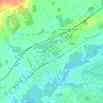
Name: Topografische Karte Kingston, Höhe, Relief.
Durchschnittliche Höhe: 30 m
Minimale Höhe: 13 m
Maximale Höhe: 82 m
Andere topografische Karten
Klicken Sie auf eine Karte, um ihre Topografie, ihre Höhe und ihr Relief anzuzeigen.
Blue Mountain
Canada > Nova Scotia > Municipality of the County of Kings
Blue Mountain, Municipality of the County of Kings, Kings County, Nova Scotia, B4N 3V8, Canada
Durchschnittliche Höhe: 224 m
Dalhousie Road
Canada > Nova Scotia > Municipality of the County of Kings
Dalhousie Road, East Dalhousie, Municipality of the County of Kings, Kings County, Nova Scotia, B0R 1H0, Canada
Durchschnittliche Höhe: 207 m
Mountain Front
Canada > Nova Scotia > Municipality of the County of Kings
Mountain Front, Municipality of the County of Kings, Kings County, Nova Scotia, Canada
Durchschnittliche Höhe: 166 m
Lake George
Canada > Nova Scotia > Municipality of the County of Kings
Lake George, Municipality of the County of Kings, Kings County, Nova Scotia, B0P 1C0, Canada
Durchschnittliche Höhe: 227 m
Ogilvie
Canada > Nova Scotia > Municipality of the County of Kings
Ogilvie, Municipality of the County of Kings, Kings County, Nova Scotia, B0P 1E0, Canada
Durchschnittliche Höhe: 41 m
Ross Creek
Canada > Nova Scotia > Municipality of the County of Kings
Ross Creek, Municipality of the County of Kings, Kings County, Nova Scotia, B0P 1H0, Canada
Durchschnittliche Höhe: 100 m