
Topografische Karte Slieve Donard
Interaktive Karte
Klicken Sie auf die Karte, um die Höhe anzuzeigen.
Über diese Karte
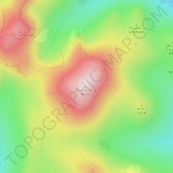
Name: Topografische Karte Slieve Donard, Höhe, Relief.
Durchschnittliche Höhe: 505 m
Minimale Höhe: 215 m
Maximale Höhe: 843 m
Andere topografische Karten
Klicken Sie auf eine Karte, um ihre Topografie, ihre Höhe und ihr Relief anzuzeigen.
Hillhall
United Kingdom > Northern Ireland > County Down
Hillhall, County Down, Northern Ireland, BT27 5JA, United Kingdom
Durchschnittliche Höhe: 61 m
Benraw
United Kingdom > Northern Ireland > County Down
Benraw, County Down, Ulster, Northern Ireland, United Kingdom
Durchschnittliche Höhe: 182 m
Newry
United Kingdom > Northern Ireland > County Down
Newry, County Down, Northern Ireland, United Kingdom
Durchschnittliche Höhe: 73 m
Banbridge
United Kingdom > Northern Ireland > County Down
Banbridge, County Down, Northern Ireland, BT32 3DB, United Kingdom
Durchschnittliche Höhe: 90 m
Carryduff
United Kingdom > Northern Ireland > County Down > Carryduff
Carryduff, County Down, Northern Ireland, BT8 8DN, United Kingdom
Durchschnittliche Höhe: 110 m
Newry
United Kingdom > Northern Ireland > County Down > Newry
Newry, County Down, Northern Ireland, BT34 1DG, United Kingdom
Durchschnittliche Höhe: 129 m