
Topografische Karte Oogly Hoogly Creek
Interaktive Karte
Klicken Sie auf die Karte, um die Höhe anzuzeigen.
Über diese Karte
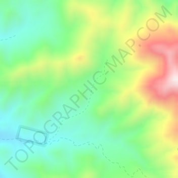
Name: Topografische Karte Oogly Hoogly Creek, Höhe, Relief.
Ort: Oogly Hoogly Creek, Cochise County, Arizona, USA (32.05503 -109.36258 32.07082 -109.35022)
Durchschnittliche Höhe: 1.912 m
Minimale Höhe: 1.692 m
Maximale Höhe: 2.304 m
Andere topografische Karten
Klicken Sie auf eine Karte, um ihre Topografie, ihre Höhe und ihr Relief anzuzeigen.
South Fort
USA > Arizona > South Fort
South Fort, Yavapai County, Arizona, USA
Durchschnittliche Höhe: 1.777 m
Castle Mountains
Castle Mountains, Pima County, Arizona, USA
Durchschnittliche Höhe: 741 m
Sevenmile Mountains
Sevenmile Mountains, Gila County, Arizona, USA
Durchschnittliche Höhe: 1.511 m
Mount Lemmon
Mount Lemmon, Pima County, Arizona, 85619, USA
Durchschnittliche Höhe: 2.514 m
Superstition Mountains
Superstition Mountains, Pinal County, Arizona, USA
Durchschnittliche Höhe: 1.125 m
Organ Pipe Cactus National Monument
Organ Pipe Cactus National Monument, Dripping Springs Trail, Pima County, Arizona, USA
Durchschnittliche Höhe: 494 m
Laguna Mountains
Laguna Mountains, Yuma, Yuma County, Arizona, USA
Durchschnittliche Höhe: 141 m
Grand Canyon National Park
Grand Canyon National Park, Swamp Ridge Road, Coconino County, Arizona, USA
Durchschnittliche Höhe: 1.685 m