
Topografische Karte In Amguel
Interaktive Karte
Klicken Sie auf die Karte, um die Höhe anzuzeigen.
In Amguel
In Amguel lies at an elevation of 981 metres (3,219 ft) on the southern bank of a wadi that cuts through a plateau lying to the northwest of the Hoggar Mountains. The numerous wadis in the area support some vegetation, but beyond them the land is barren and rocky.
Über diese Karte
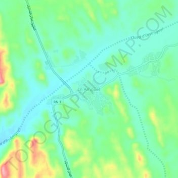
Name: Topografische Karte In Amguel, Höhe, Relief.
Ort: In Amguel, de Tamanrasset District, Tamanrasset, Algeria (23.67098 5.13094 23.71098 5.17094)
Durchschnittliche Höhe: 992 m
Minimale Höhe: 954 m
Maximale Höhe: 1.086 m