
Topografische Karte Clear Lake
Interaktive Karte
Klicken Sie auf die Karte, um die Höhe anzuzeigen.
Über diese Karte
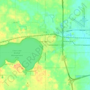
Name: Topografische Karte Clear Lake, Höhe, Relief.
Ort: Clear Lake, Cerro Gordo County, Iowa, 50428, United States (43.10469 -93.43827 43.16273 -93.32001)
Durchschnittliche Höhe: 373 m
Minimale Höhe: 357 m
Maximale Höhe: 398 m
Andere topografische Karten
Klicken Sie auf eine Karte, um ihre Topografie, ihre Höhe und ihr Relief anzuzeigen.
Rockwell
United States > Iowa > Cerro Gordo County
Rockwell, Cerro Gordo County, Iowa, United States
Durchschnittliche Höhe: 343 m
Mason City
United States > Iowa > Cerro Gordo County
Mason City, Cerro Gordo County, Iowa, United States
Durchschnittliche Höhe: 352 m
Clear Lake
United States > Iowa > Cerro Gordo County > Clear Lake > Clear Lake
Clear Lake, Cerro Gordo County, Iowa, 50428, United States
Durchschnittliche Höhe: 373 m
Swaledale
United States > Iowa > Cerro Gordo County
Swaledale, Cerro Gordo County, Iowa, United States
Durchschnittliche Höhe: 352 m