
Topografische Karte Magalies
Interaktive Karte
Klicken Sie auf die Karte, um die Höhe anzuzeigen.
Über diese Karte
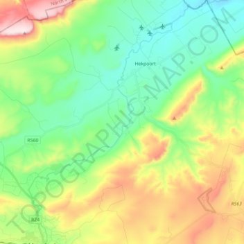
Name: Topografische Karte Magalies, Höhe, Relief.
Durchschnittliche Höhe: 1.434 m
Minimale Höhe: 1.222 m
Maximale Höhe: 1.856 m
Andere topografische Karten
Klicken Sie auf eine Karte, um ihre Topografie, ihre Höhe und ihr Relief anzuzeigen.
Cradle Moon Lake
South Africa > Gauteng > West Rand District Municipality > Mogale City Local Municipality
Cradle Moon Lake, Mogale City Ward 33, Mogale City Local Municipality, West Rand District Municipality, Gauteng, South Africa
Durchschnittliche Höhe: 1.372 m
Rietvallei 241-IQ
South Africa > Gauteng > West Rand District Municipality > Mogale City Local Municipality
Rietvallei 241-IQ, Mogale City Local Municipality, West Rand District Municipality, Gauteng, 1754, South Africa
Durchschnittliche Höhe: 1.684 m
Magaliesburg
South Africa > Gauteng > West Rand District Municipality > Mogale City Local Municipality
Magaliesburg, Mogale City Local Municipality, West Rand District Municipality, Gauteng, 1791, South Africa
Durchschnittliche Höhe: 1.504 m
Muldersdrift
South Africa > Gauteng > West Rand District Municipality > Mogale City Local Municipality
Muldersdrift, Mogale City Local Municipality, West Rand District Municipality, Gauteng, 1747, South Africa
Durchschnittliche Höhe: 1.449 m
Hekpoort
South Africa > Gauteng > West Rand District Municipality > Mogale City Local Municipality
Hekpoort, Mogale City Local Municipality, West Rand District Municipality, Gauteng, South Africa
Durchschnittliche Höhe: 1.278 m