
Topografische Karte Fernie
Interaktive Karte
Klicken Sie auf die Karte, um die Höhe anzuzeigen.
Über diese Karte
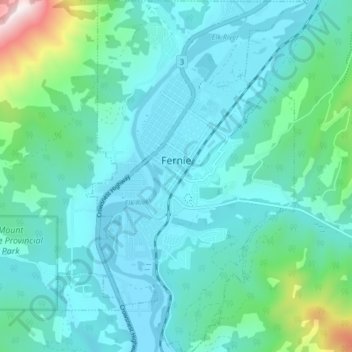
Name: Topografische Karte Fernie, Höhe, Relief.
Durchschnittliche Höhe: 1.141 m
Minimale Höhe: 983 m
Maximale Höhe: 2.010 m
Andere topografische Karten
Klicken Sie auf eine Karte, um ihre Topografie, ihre Höhe und ihr Relief anzuzeigen.
Invermere
Canada > Colombie-Britannique > Regional District of East Kootenay > Invermere
Invermere, Regional District of East Kootenay, Colombie-Britannique, Canada
Durchschnittliche Höhe: 876 m
Kootenay National Park
Canada > Colombie-Britannique > Regional District of East Kootenay
Kootenay National Park, Regional District of East Kootenay, Colombie-Britannique, Canada
Durchschnittliche Höhe: 1.832 m
Kootenay National Park
Canada > Colombie-Britannique > Regional District of East Kootenay
Kootenay National Park, Regional District of East Kootenay, Colombie-Britannique, Canada
Durchschnittliche Höhe: 1.832 m
Shuswap
Canada > Colombie-Britannique > Regional District of East Kootenay > Area F (Columbia Lake/Windermere Lake) > Shuswap
Shuswap, Area F (Columbia Lake/Windermere Lake), Regional District of East Kootenay, Colombie-Britannique, V0A 1K3, Canada
Durchschnittliche Höhe: 926 m