Geolokalisieren

Topografische Karte Tatopani

Interaktive Karte

Klicken Sie auf die Karte, um die Höhe anzuzeigen.

Über diese Karte

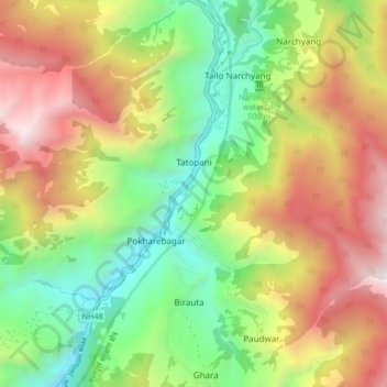
Name: Topografische Karte Tatopani, Höhe, Relief.

Ort: Tatopani, Annapurna, म्याग्दी, Gandaki, Népal (28.47118 83.57239 28.51198 83.65537)

Durchschnittliche Höhe: 2.031 m

Minimale Höhe: 1.096 m

Maximale Höhe: 3.247 m

Andere topografische Karten

Klicken Sie auf eine Karte, um ihre Topografie, ihre Höhe und ihr Relief anzuzeigen.

Khibang

Népal > म्याग्दी

Khibang, Ghara, Annapurna, म्याग्दी, Gandaki, Népal

Durchschnittliche Höhe: 1.955 m

Ghorepani

Népal > म्याग्दी

Ghorepani, Ghara, Annapurna, म्याग्दी, Gandaki, Népal

Durchschnittliche Höhe: 2.796 m

Darbang

Népal > म्याग्दी

Darbang, Malika, म्याग्दी, Gandaki, 33208, Népal

Durchschnittliche Höhe: 1.744 m

Chitre

Népal > म्याग्दी

Chitre, Shikha, Annapurna, म्याग्दी, Gandaki, Népal

Durchschnittliche Höhe: 2.508 m

Dhaulagiri

Népal > म्याग्दी > Mudi

Dhaulagiri, Mudi, Dhaulagiri, म्याग्दी, Gandaki, Népal

Durchschnittliche Höhe: 7.321 m