
Topografische Karte Madagascar
Interaktive Karte
Klicken Sie auf die Karte, um die Höhe anzuzeigen.
Madagascar
Madagascar can be divided into five general geographical regions: the east coast, the Tsaratanana Massif, the Central Highlands, the west coast, and the southwest. The highest elevations parallel the east coast. The total size is 587,040 square kilometres (226,660 sq mi), which makes it the world's second largest island country.
Über diese Karte
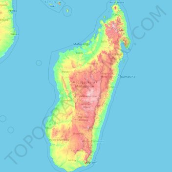
Name: Topografische Karte Madagascar, Höhe, Relief.
Ort: Madagascar, Province d’Antananarivo, Madagascar (-25.60614 43.22023 -11.95203 50.48606)
Durchschnittliche Höhe: 144 m
Minimale Höhe: -1 m
Maximale Höhe: 2.699 m