
Topografische Karte Kechnec
Interaktive Karte
Klicken Sie auf die Karte, um die Höhe anzuzeigen.
Kechnec
The village lies at an altitude of 180 metres and covers an area of 10.211 km2. The municipality is part of the administrative units Košice-okolie District and Košice Region. It has a population of about 1080 people.
Über diese Karte
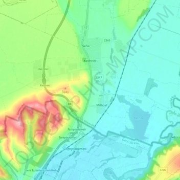
Name: Topografische Karte Kechnec, Höhe, Relief.
Durchschnittliche Höhe: 188 m
Minimale Höhe: 154 m
Maximale Höhe: 281 m
Andere topografische Karten
Klicken Sie auf eine Karte, um ihre Topografie, ihre Höhe und ihr Relief anzuzeigen.