
Topografische Karte Williamsport
Interaktive Karte
Klicken Sie auf die Karte, um die Höhe anzuzeigen.
Über diese Karte
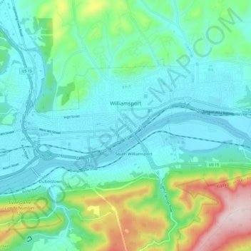
Name: Topografische Karte Williamsport, Höhe, Relief.
Ort: Williamsport, Lycoming County, Pennsylvania, United States (41.21872 -77.09593 41.26456 -76.98168)
Durchschnittliche Höhe: 253 m
Minimale Höhe: 149 m
Maximale Höhe: 615 m
Andere topografische Karten
Klicken Sie auf eine Karte, um ihre Topografie, ihre Höhe und ihr Relief anzuzeigen.
Muncy Township
United States > Pennsylvania > Lycoming County
Muncy Township, Lycoming County, Pennsylvania, United States
Durchschnittliche Höhe: 229 m
Cummings Township
United States > Pennsylvania > Lycoming County
Cummings Township, Lycoming County, Pennsylvania, 17776, United States
Durchschnittliche Höhe: 458 m
Bear Run
United States > Pennsylvania > Lycoming County > Pine Township
Bear Run, Pine Township, Lycoming County, Pennsylvania, United States
Durchschnittliche Höhe: 418 m
Raccoon Mountain
United States > Pennsylvania > Lycoming County
Raccoon Mountain, Lycoming County, Pennsylvania, 17702, United States
Durchschnittliche Höhe: 379 m
Cedar Run
United States > Pennsylvania > Lycoming County
Cedar Run, Lycoming County, Pennsylvania, 17727, United States
Durchschnittliche Höhe: 405 m
Waterville
United States > Pennsylvania > Lycoming County
Waterville, Lycoming County, Pennsylvania, United States
Durchschnittliche Höhe: 390 m
Hughesville
United States > Pennsylvania > Lycoming County > Hughesville
Hughesville, Lycoming County, Pennsylvania, United States
Durchschnittliche Höhe: 182 m
Lycoming County
United States > Pennsylvania > Lycoming County
Lycoming County, Pennsylvania, United States
Durchschnittliche Höhe: 415 m
North Eldred
United States > Pennsylvania > Lycoming County > Eldred Township
North Eldred, Eldred Township, Lycoming County, Pennsylvania, United States
Durchschnittliche Höhe: 345 m