
Topografische Karte Arnoldsburg
Interaktive Karte
Klicken Sie auf die Karte, um die Höhe anzuzeigen.
Über diese Karte
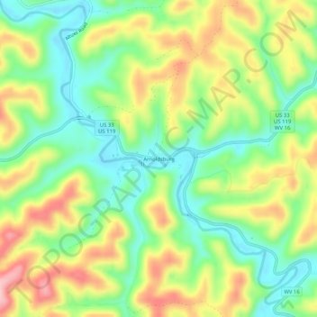
Name: Topografische Karte Arnoldsburg, Höhe, Relief.
Durchschnittliche Höhe: 287 m
Minimale Höhe: 213 m
Maximale Höhe: 389 m
Arnoldsburg (also Arnoldsburgh) is an unincorporated community in Calhoun County, West Virginia, United States. It lies along U.S. Route 33 at the point where West Virginia Route 16 heads southward; it is several miles south of the county seat of Grantsville. Its elevation is 738 feet (225 m). The West Fork Little Kanawha River flows through the community. It has a post office with the ZIP code 25234.
Andere topografische Karten
Klicken Sie auf eine Karte, um ihre Topografie, ihre Höhe und ihr Relief anzuzeigen.
Mount Zion
United States > West Virginia > Calhoun County
Mount Zion, Calhoun County, West Virginia, 26151, United States
Durchschnittliche Höhe: 312 m
Orma
United States > West Virginia > Calhoun County
Orma, Calhoun County, West Virginia, 25268, United States
Durchschnittliche Höhe: 299 m
Millstone
United States > West Virginia > Calhoun County
Millstone, Calhoun County, West Virginia, 25261, United States
Durchschnittliche Höhe: 310 m
Chloe
United States > West Virginia > Calhoun County
Chloe, Calhoun County, West Virginia, 25235, United States
Durchschnittliche Höhe: 314 m
Bigbend
United States > West Virginia > Calhoun County
Bigbend, Calhoun County, West Virginia, 26152, United States
Durchschnittliche Höhe: 270 m
Purdy
United States > West Virginia > Calhoun County > Purdy
Purdy, Calhoun County, West Virginia, 26136, United States
Durchschnittliche Höhe: 263 m
Ayers
United States > West Virginia > Calhoun County
Ayers, Calhoun County, West Virginia, 26136, United States
Durchschnittliche Höhe: 289 m
Grantsville
United States > West Virginia > Calhoun County
Grantsville, Calhoun County, West Virginia, 26147, United States
Durchschnittliche Höhe: 261 m