
Topografische Karte Montemorelos
Interaktive Karte
Klicken Sie auf die Karte, um die Höhe anzuzeigen.
Über diese Karte
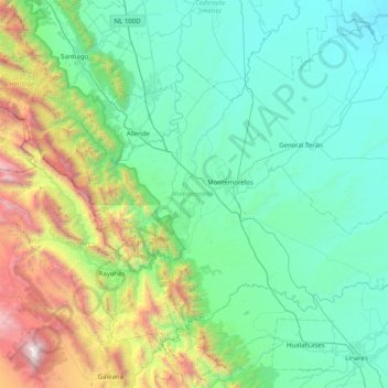
Name: Topografische Karte Montemorelos, Höhe, Relief.
Ort: Montemorelos, Nuevo León, México (24.91165 -100.17106 25.42034 -99.36926)
Durchschnittliche Höhe: 872 m
Minimale Höhe: 184 m
Maximale Höhe: 3.719 m
Andere topografische Karten
Klicken Sie auf eine Karte, um ihre Topografie, ihre Höhe und ihr Relief anzuzeigen.
El Ébano
México > Nuevo León > Sabinas Hidalgo
El Ébano, Sabinas Hidalgo, Nuevo León, México
Durchschnittliche Höhe: 315 m
El Fraile
México > Nuevo León > García
El Fraile, García, Nuevo León, 66023, México
Durchschnittliche Höhe: 695 m
Ampliación Cerritos
México > Nuevo León > Ampliación Cerritos
Ampliación Cerritos, García, Nuevo León, México
Durchschnittliche Höhe: 756 m
Guadalupe
México > Nuevo León > Guadalupe
Guadalupe, Nuevo León, 67180, México
Durchschnittliche Höhe: 594 m
General Escobedo
México > Nuevo León > General Escobedo
General Escobedo, Nuevo León, 66050, México
Durchschnittliche Höhe: 580 m
Monterrey
México > Nuevo León > Monterrey > Monterrey
Monterrey, Nuevo León, 64570, México
Durchschnittliche Höhe: 753 m
Cadereyta Jiménez
México > Nuevo León > Cadereyta Jiménez
Cadereyta Jiménez, Nuevo León, 67450, México
Durchschnittliche Höhe: 335 m
San Pedro Garza García
México > Nuevo León > San Pedro Garza García
San Pedro Garza García, Nuevo León, 66210, México
Durchschnittliche Höhe: 798 m
San Nicolás de los Garza
México > Nuevo León > San Nicolás de los Garza
San Nicolás de los Garza, Nuevo León, 66443, México
Durchschnittliche Höhe: 584 m