
Spenden
Rüsten Sie sich für Ihr nächstes Abenteuer:
Als Amazon-Partner erhält diese Website eine Provision für qualifizierte Käufe, ohne zusätzliche Kosten für Sie.
Topografische Karte Blomidon
Klicken Sie auf die Karte, um die Höhe anzuzeigen.
Spenden
Rüsten Sie sich für Ihr nächstes Abenteuer:
Als Amazon-Partner erhält diese Website eine Provision für qualifizierte Käufe, ohne zusätzliche Kosten für Sie.
Über diese Karte
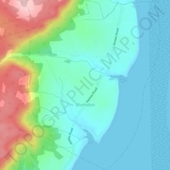
Name: Topografische Karte Blomidon, Höhe, Relief.
Durchschnittliche Höhe: 56 m
Minimale Höhe: -1 m
Maximale Höhe: 215 m
Spenden
Rüsten Sie sich für Ihr nächstes Abenteuer:
Als Amazon-Partner erhält diese Website eine Provision für qualifizierte Käufe, ohne zusätzliche Kosten für Sie.
Andere topografische Karten
Klicken Sie auf eine Karte, um ihre Topografie, ihre Höhe und ihr Relief anzuzeigen.
Annapolis Valley
Canada > Nova Scotia > Municipality of the County of Kings > Auburn
Durchschnittliche Höhe: 77 m
Starrs Point
Canada > Nova Scotia > Municipality of the County of Kings > Port Williams
Durchschnittliche Höhe: 3 m
Gaspereau Mountain
Canada > Nova Scotia > Municipality of the County of Kings > Forest Hill
Durchschnittliche Höhe: 185 m
Loon Lake Channel
Canada > Nova Scotia > Municipality of the County of Kings > Aylesford Lake
Durchschnittliche Höhe: 220 m
Spenden
Rüsten Sie sich für Ihr nächstes Abenteuer:
Als Amazon-Partner erhält diese Website eine Provision für qualifizierte Käufe, ohne zusätzliche Kosten für Sie.
Gaspereau
Canada > Nova Scotia > Municipality of the County of Kings > Gaspereau
Durchschnittliche Höhe: 95 m
Cape Split
Canada > Nova Scotia > Municipality of the County of Kings > Scots Bay
Durchschnittliche Höhe: 6 m
Dalhousie Road
Canada > Nova Scotia > Municipality of the County of Kings
Durchschnittliche Höhe: 207 m