
Topografische Karte Salmo
Interaktive Karte
Klicken Sie auf die Karte, um die Höhe anzuzeigen.
Über diese Karte
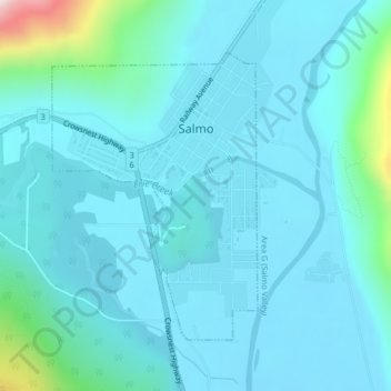
Name: Topografische Karte Salmo, Höhe, Relief.
Durchschnittliche Höhe: 715 m
Minimale Höhe: 647 m
Maximale Höhe: 1.228 m
Andere topografische Karten
Klicken Sie auf eine Karte, um ihre Topografie, ihre Höhe und ihr Relief anzuzeigen.
Lardeau
Canada > Colombie-Britannique > Regional District of Central Kootenay > Area D (Lardeau Valley/Duncan Lake)
Lardeau, Area D (Lardeau Valley/Duncan Lake), Regional District of Central Kootenay, Colombie-Britannique, V0G 1B0, Canada
Durchschnittliche Höhe: 751 m
Kootenay Lake Provincial Park - Coffee Creek Site
Canada > Colombie-Britannique > Regional District of Central Kootenay > Area D (Lardeau Valley/Duncan Lake)
Kootenay Lake Provincial Park - Coffee Creek Site, Area D (Lardeau Valley/Duncan Lake), Regional District of Central Kootenay, Colombie-Britannique, Canada
Durchschnittliche Höhe: 700 m
Area C
Canada > Colombie-Britannique > Regional District of Central Kootenay > Area C
Area C, Regional District of Central Kootenay, Colombie-Britannique, V0B 1G7, Canada
Durchschnittliche Höhe: 1.431 m
Castlegar
Canada > Colombie-Britannique > Regional District of Central Kootenay
Castlegar, Regional District of Central Kootenay, Colombie-Britannique, Canada
Durchschnittliche Höhe: 831 m