
Topografische Karte Gwanda
Interaktive Karte
Klicken Sie auf die Karte, um die Höhe anzuzeigen.
Gwanda
The town is located 134 kilometres (83 mi), by road, south east of the city of Bulawayo, Zimbabwe's second largest city. This location lies on the Bulawayo–Beitbridge Road and the Beitbridge Bulawayo Railway. The town of Beitbridge, at Zimbabwe's border with the Republic of South Africa, lies approximately 197 kilometres (122 mi), further southeast on Highway A-6. The coordinates of Gwanda, Zimbabwe are: 20°56'20.0"S, 29°01'07.0"E (Latitude:-20.938889; Longitude:29.018611). Gwanda sits at an average elevation of 3,300 feet (1,006 m) above mean sea level. Gwanda is known to have long, hot summers, and short, cool winters. Gwanda is also quite dry as compared to the rest of the country, and is therefore prone to drought.
Über diese Karte
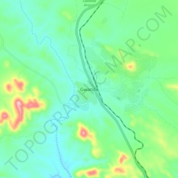
Name: Topografische Karte Gwanda, Höhe, Relief.
Ort: Gwanda, Matabeleland South Province, Zimbabwe (-20.98143 28.96369 -20.90143 29.04369)
Durchschnittliche Höhe: 1.012 m
Minimale Höhe: 941 m
Maximale Höhe: 1.228 m