
Topografische Karte La Grande Vallée
Interaktive Karte
Klicken Sie auf die Karte, um die Höhe anzuzeigen.
Über diese Karte
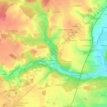
Name: Topografische Karte La Grande Vallée, Höhe, Relief.
Durchschnittliche Höhe: 122 m
Minimale Höhe: 75 m
Maximale Höhe: 156 m
Andere topografische Karten
Klicken Sie auf eine Karte, um ihre Topografie, ihre Höhe und ihr Relief anzuzeigen.
La Grande Vallée
France > Centre-Val de Loire > Indre-et-Loire > Villedômer
La Grande Vallée, Villedômer, Loches, Indre-et-Loire, Centre-Val de Loire, France métropolitaine, 37110, France
Durchschnittliche Höhe: 121 m
Le Boulay
France > Centre-Val de Loire > Indre-et-Loire > Villedômer > Le Boulay
Le Boulay, Villedômer, Loches, Indre-et-Loire, Centre-Val de Loire, France métropolitaine, 37110, France
Durchschnittliche Höhe: 118 m
La Grand’ Vallée
France > Centre-Val de Loire > Indre-et-Loire > Villedômer > La Grand’ Vallée
La Grand’ Vallée, Villedômer, Loches, Indre-et-Loire, Centre-Val de Loire, France métropolitaine, 37110, France
Durchschnittliche Höhe: 120 m