
Spenden
Rüsten Sie sich für Ihr nächstes Abenteuer:
Als Amazon-Partner erhält diese Website eine Provision für qualifizierte Käufe, ohne zusätzliche Kosten für Sie.
Topografische Karte Redington Shores
Klicken Sie auf die Karte, um die Höhe anzuzeigen.
Spenden
Rüsten Sie sich für Ihr nächstes Abenteuer:
Als Amazon-Partner erhält diese Website eine Provision für qualifizierte Käufe, ohne zusätzliche Kosten für Sie.
Redington Shores
According to the United States Census Bureau, the town has a total area of 1.2 square miles (3.1 km2), of which 0.4 square miles (1.0 km2) is land and 0.8 square miles (2.1 km2) (67.50%) is water. According to Elevation Map Logs, the elevation of Redington Shores is just one meter above sea level.
Spenden
Rüsten Sie sich für Ihr nächstes Abenteuer:
Als Amazon-Partner erhält diese Website eine Provision für qualifizierte Käufe, ohne zusätzliche Kosten für Sie.
Über diese Karte
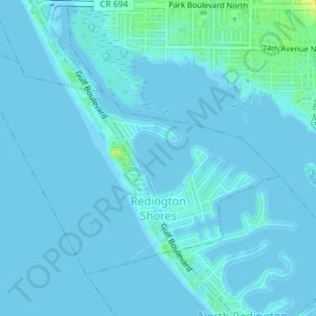
Name: Topografische Karte Redington Shores, Höhe, Relief.
Ort: Redington Shores, Pinellas County, Florida, United States (27.82038 -82.84810 27.84057 -82.81703)
Durchschnittliche Höhe: 2 m
Minimale Höhe: -2 m
Maximale Höhe: 21 m
Spenden
Rüsten Sie sich für Ihr nächstes Abenteuer:
Als Amazon-Partner erhält diese Website eine Provision für qualifizierte Käufe, ohne zusätzliche Kosten für Sie.
Andere topografische Karten
Klicken Sie auf eine Karte, um ihre Topografie, ihre Höhe und ihr Relief anzuzeigen.
Saint Joseph Sound
United States > Florida > Pinellas County > Palm Harbor
Durchschnittliche Höhe: 0 m
Spenden
Rüsten Sie sich für Ihr nächstes Abenteuer:
Als Amazon-Partner erhält diese Website eine Provision für qualifizierte Käufe, ohne zusätzliche Kosten für Sie.
A.L. Anderson Park
United States > Florida > Pinellas County > Tarpon Springs
Durchschnittliche Höhe: 5 m
Blue Heron Lake
United States > Florida > Pinellas County > Saint Petersburg
Durchschnittliche Höhe: 5 m
Spenden
Rüsten Sie sich für Ihr nächstes Abenteuer:
Als Amazon-Partner erhält diese Website eine Provision für qualifizierte Käufe, ohne zusätzliche Kosten für Sie.
Pine Key
United States > Florida > Pinellas County > Tierra Verde > Tierra Verde
Durchschnittliche Höhe: 1 m
Spenden
Rüsten Sie sich für Ihr nächstes Abenteuer:
Als Amazon-Partner erhält diese Website eine Provision für qualifizierte Käufe, ohne zusätzliche Kosten für Sie.
Largo
United States > Florida > Pinellas County > Largo
In 2010, Largo's total area was 18.6 square miles (48.1 km2), of which 17.6 square miles (45.6 km2) was land and 0.97 square miles (2.5 km2), or 5.22%, was water. As of 2004, there were 651 acres (2.6 km2) of park lands. The city's lowest elevation is sea level. At its highest, the city's elevation is about 69…
Durchschnittliche Höhe: 5 m
Saint Petersburg
United States > Florida > Pinellas County > Saint Petersburg
Durchschnittliche Höhe: 3 m
Coffee Pot Bayou
United States > Florida > Pinellas County > Saint Petersburg
Durchschnittliche Höhe: 7 m
Spenden
Rüsten Sie sich für Ihr nächstes Abenteuer:
Als Amazon-Partner erhält diese Website eine Provision für qualifizierte Käufe, ohne zusätzliche Kosten für Sie.
Ridgecrest
United States > Florida > Pinellas County > Largo > Ridgecrest
Durchschnittliche Höhe: 18 m
Spenden
Rüsten Sie sich für Ihr nächstes Abenteuer:
Als Amazon-Partner erhält diese Website eine Provision für qualifizierte Käufe, ohne zusätzliche Kosten für Sie.
Spenden
Rüsten Sie sich für Ihr nächstes Abenteuer:
Als Amazon-Partner erhält diese Website eine Provision für qualifizierte Käufe, ohne zusätzliche Kosten für Sie.
Sunshine Beach
United States > Florida > Pinellas County > Treasure Island
Durchschnittliche Höhe: 1 m
West and East Lealman
United States > Florida > Pinellas County
"West and East Lealman" was located at 27°49′12″N 82°41′12″W / 27.82000°N 82.68667°W / 27.82000; -82.68667 (27.820103, -82.686670). The community is adjacent to the cities of Pinellas Park, St. Petersburg, and Kenneth City. The elevation is 49 feet (15 m) above sea level.
Durchschnittliche Höhe: 10 m
Spenden
Rüsten Sie sich für Ihr nächstes Abenteuer:
Als Amazon-Partner erhält diese Website eine Provision für qualifizierte Käufe, ohne zusätzliche Kosten für Sie.
West and East Lealman
United States > Florida > Pinellas County > Saint Petersburg
"West and East Lealman" was located at 27°49′12″N 82°41′12″W / 27.82000°N 82.68667°W / 27.82000; -82.68667 (27.820103, -82.686670). The community is adjacent to the cities of Pinellas Park, St. Petersburg, and Kenneth City. The elevation is 49 feet (15 m) above sea level.
Durchschnittliche Höhe: 12 m
Spenden
Rüsten Sie sich für Ihr nächstes Abenteuer:
Als Amazon-Partner erhält diese Website eine Provision für qualifizierte Käufe, ohne zusätzliche Kosten für Sie.
Howard Park Beach
United States > Florida > Pinellas County > Tarpon Springs
Durchschnittliche Höhe: 0 m
Spenden
Rüsten Sie sich für Ihr nächstes Abenteuer:
Als Amazon-Partner erhält diese Website eine Provision für qualifizierte Käufe, ohne zusätzliche Kosten für Sie.
Spenden
Rüsten Sie sich für Ihr nächstes Abenteuer:
Als Amazon-Partner erhält diese Website eine Provision für qualifizierte Käufe, ohne zusätzliche Kosten für Sie.
Lealman
United States > Florida > Pinellas County
Lealman is located at 27°49′10″N 82°41′4″W / 27.81944°N 82.68444°W / 27.81944; -82.68444 (27.8197, -82.6846). The community is bordered by the city of Pinellas Park to the north, St. Petersburg to the east and south, and by the town of West Lealman to the west. The elevation is 49 feet (15…
Durchschnittliche Höhe: 13 m
Spenden
Rüsten Sie sich für Ihr nächstes Abenteuer:
Als Amazon-Partner erhält diese Website eine Provision für qualifizierte Käufe, ohne zusätzliche Kosten für Sie.
Taylor Park
United States > Florida > Pinellas County > Largo > Ridgecrest
Durchschnittliche Höhe: 18 m
Spenden
Rüsten Sie sich für Ihr nächstes Abenteuer:
Als Amazon-Partner erhält diese Website eine Provision für qualifizierte Käufe, ohne zusätzliche Kosten für Sie.