Geolokalisieren

Topografische Karte Elk Island

Interaktive Karte

Klicken Sie auf die Karte, um die Höhe anzuzeigen.

Über diese Karte

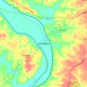
Name: Topografische Karte Elk Island, Höhe, Relief.

Ort: Elk Island, Goochland County, Virginia, VS (37.68587 -78.13940 37.74235 -78.08558)

Durchschnittliche Höhe: 79 m

Minimale Höhe: 50 m

Maximale Höhe: 114 m

Andere topografische Karten

Klicken Sie auf eine Karte, um ihre Topografie, ihre Höhe und ihr Relief anzuzeigen.

Rockingham County

VS > Virginia

Rockingham County, Virginia, VS

Durchschnittliche Höhe: 525 m

Greenfields

VS > Virginia > Greenfields

Greenfields, Albemarle County, Virginia, 22908, VS

Durchschnittliche Höhe: 136 m

Arlington

VS > Virginia > Arlington

Arlington, Arlington County, Virginia, VS

Durchschnittliche Höhe: 51 m

Newport News City

VS > Virginia

Newport News City, Virginia, VS

Durchschnittliche Höhe: 6 m

Valley Oaks

VS > Virginia > Valley Oaks

Valley Oaks, Hanover County, Virginia, VS

Durchschnittliche Höhe: 50 m

Rosewell

VS > Virginia > Rosewell

Rosewell, Gloucester County, Virginia, VS

Durchschnittliche Höhe: 4 m

Dilbeck

VS > Virginia > Dilbeck

Dilbeck, Shenandoah County, Virginia, VS

Durchschnittliche Höhe: 317 m

Adams Peak

VS > Virginia

Adams Peak, Rockbridge County, Virginia, VS

Durchschnittliche Höhe: 611 m

Crozet

VS > Virginia > Crozet

Crozet, Saint George Street, Crozet, Albemarle County, Virginia, 22932, VS

Durchschnittliche Höhe: 234 m

Dominion

VS > Virginia > Dominion

Dominion, Lee County, Virginia, 24282, VS

Durchschnittliche Höhe: 600 m

Wythe County

VS > Virginia

Wythe County, Virginia, VS

Durchschnittliche Höhe: 797 m

Richmond City

VS > Virginia > Richmond City

Richmond, Richmond City, Virginia, 23298, VS

Durchschnittliche Höhe: 53 m

Key West

VS > Virginia > Key West

Key West, Albemarle County, Virginia, 22909, VS

Durchschnittliche Höhe: 145 m