
Topografische Karte Newport
Interaktive Karte
Klicken Sie auf die Karte, um die Höhe anzuzeigen.
Über diese Karte
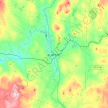
Name: Topografische Karte Newport, Höhe, Relief.
Ort: Newport, Sullivan County, New Hampshire, United States (43.30758 -72.26950 43.42379 -72.12587)
Durchschnittliche Höhe: 339 m
Minimale Höhe: 187 m
Maximale Höhe: 600 m
Newport is drained by the west-flowing Sugar River and its South Branch, with the town center at their confluence. The North Branch joins the Sugar River north of Newport village and east of North Newport. The entire town is part of the Connecticut River watershed. The highest point in town is along its southern border, where an unnamed ridge has an elevation of approximately 1,920 feet (590 m) above sea level.
Andere topografische Karten
Klicken Sie auf eine Karte, um ihre Topografie, ihre Höhe und ihr Relief anzuzeigen.
East Unity
United States > New Hampshire > Sullivan County > Unity
East Unity, Unity, Sullivan County, New Hampshire, United States
Durchschnittliche Höhe: 399 m
Sunapee
United States > New Hampshire > Sullivan County
Sunapee, Sullivan County, New Hampshire, United States
Durchschnittliche Höhe: 363 m
Croydon
United States > New Hampshire > Sullivan County
Croydon, Sullivan County, New Hampshire, United States
Durchschnittliche Höhe: 372 m
Ryder Corner
United States > New Hampshire > Sullivan County > Croydon
Ryder Corner, Croydon, Sullivan County, New Hampshire, 03754, United States
Durchschnittliche Höhe: 352 m
Grantham
United States > New Hampshire > Sullivan County
Grantham, Sullivan County, New Hampshire, 03753, United States
Durchschnittliche Höhe: 419 m
Unity
United States > New Hampshire > Sullivan County
Unity, Sullivan County, New Hampshire, United States
Durchschnittliche Höhe: 369 m
Green Mountain
United States > New Hampshire > Sullivan County > Claremont
Green Mountain, Claremont, Sullivan County, New Hampshire, United States
Durchschnittliche Höhe: 446 m
Goshen
United States > New Hampshire > Sullivan County > Goshen
Goshen, Sullivan County, New Hampshire, 03752, United States
Durchschnittliche Höhe: 419 m
Eastman
United States > New Hampshire > Sullivan County > Grantham > Eastman
Eastman, Grantham, Sullivan County, New Hampshire, 03753, United States
Durchschnittliche Höhe: 347 m
Acworth
United States > New Hampshire > Sullivan County
Acworth, Sullivan County, New Hampshire, 03601, United States
Durchschnittliche Höhe: 380 m
Langdon
United States > New Hampshire > Sullivan County
Langdon, Sullivan County, New Hampshire, United States
Durchschnittliche Höhe: 239 m
Mill Hollow
United States > New Hampshire > Sullivan County > Plainfield > Mill Hollow
Mill Hollow, Plainfield, Sullivan County, New Hampshire, 03770, United States
Durchschnittliche Höhe: 313 m
Lempster
United States > New Hampshire > Sullivan County
Lempster, Sullivan County, New Hampshire, 03605, United States
Durchschnittliche Höhe: 425 m
North Grantham
United States > New Hampshire > Sullivan County > Grantham > North Grantham
North Grantham, Grantham, Sullivan County, New Hampshire, 03753, United States
Durchschnittliche Höhe: 386 m
Claremont
United States > New Hampshire > Sullivan County
Claremont, Sullivan County, New Hampshire, United States
Durchschnittliche Höhe: 236 m
Charlestown
United States > New Hampshire > Sullivan County
Charlestown, Sullivan County, New Hampshire, 03603, United States
Durchschnittliche Höhe: 256 m
Plainfield
United States > New Hampshire > Sullivan County > Plainfield
Plainfield, Sullivan County, New Hampshire, United States
Durchschnittliche Höhe: 267 m
Cornish
United States > New Hampshire > Sullivan County
Cornish, Sullivan County, New Hampshire, United States
Durchschnittliche Höhe: 272 m