
Topografische Karte La Paz
Interaktive Karte
Klicken Sie auf die Karte, um die Höhe anzuzeigen.
Über diese Karte
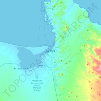
Name: Topografische Karte La Paz, Höhe, Relief.
Durchschnittliche Höhe: 114 m
Minimale Höhe: -2 m
Maximale Höhe: 1.100 m
The city, in west-central Bolivia 68 km (42 mi) southeast of Lake Titicaca, is set in a canyon created by the Choqueyapu River. It is in a bowl-like depression, part of the Amazon basin, surrounded by the high mountains of the Altiplano. Overlooking the city is the towering, triple-peaked Illimani. Its peaks are always snow-covered and can be seen from many parts of the city. At an elevation of roughly 3,650 m (11,975 ft) above sea level, La Paz is the highest capital city in the world. Due to its altitude, La Paz has an unusual subtropical highland climate, with rainy summers and dry winters.
Andere topografische Karten
Klicken Sie auf eine Karte, um ihre Topografie, ihre Höhe und ihr Relief anzuzeigen.
La Ventana
Mexico > Baja California Sur > Municipio de La Paz
La Ventana, Municipio de La Paz, Baja California Sur, 23232, Mexico
Durchschnittliche Höhe: 28 m
Isla Espíritu Santo
Mexico > Baja California Sur > Municipio de La Paz
Isla Espíritu Santo, Municipio de La Paz, Baja California Sur, Mexico
Durchschnittliche Höhe: 50 m