
Topografische Karte Bald Peak State Scenic Viewpoint
Interaktive Karte
Klicken Sie auf die Karte, um die Höhe anzuzeigen.
Über diese Karte
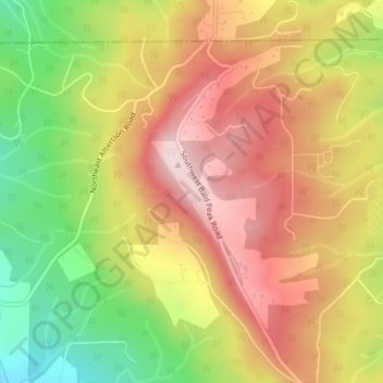
Name: Topografische Karte Bald Peak State Scenic Viewpoint, Höhe, Relief.
Durchschnittliche Höhe: 334 m
Minimale Höhe: 129 m
Maximale Höhe: 503 m
Bald Peak is on top of the Chehalem Mountains at an elevation of 1,629 feet (497 m) above sea level, the highest point in the mountain range. The closest community to the 26-acre (11 ha) park is Laurelwood, Oregon, with the park generally situated between the cities of Hillsboro to the north and Newberg to the south near the county boundary line between Yamhill and Washington counties. At the park are restrooms, picnic tables, parking, a trail, a forest with Douglas fir trees, but no drinking water. In clear weather, the park offers views of Mount Hood, Mount St. Helens, Mount Jefferson, Mount Adams, and Mount Rainier. The viewpoint also gives panoramas of the Tualatin Valley to the north of the park and the Yamhill Valley to the south, with both valleys being parts of the larger Willamette Valley.
Andere topografische Karten
Klicken Sie auf eine Karte, um ihre Topografie, ihre Höhe und ihr Relief anzuzeigen.
Newberg
United States > Oregon > Yamhill County
Newberg, Yamhill County, Oregon, United States
Durchschnittliche Höhe: 61 m
McMinnville
United States > Oregon > Yamhill County
McMinnville, Yamhill County, Oregon, 97128, United States
Durchschnittliche Höhe: 50 m
Amity Hills
United States > Oregon > Yamhill County > Amity
Amity Hills, Amity, Yamhill County, Oregon, United States
Durchschnittliche Höhe: 108 m
Sheridan
United States > Oregon > Yamhill County
Sheridan, Yamhill County, Oregon, United States
Durchschnittliche Höhe: 85 m
Lafayette
United States > Oregon > Yamhill County
Lafayette, Yamhill County, Oregon, 97127, United States
Durchschnittliche Höhe: 52 m
McGuire Reservoir
United States > Oregon > Yamhill County
McGuire Reservoir, Yamhill County, Oregon, United States
Durchschnittliche Höhe: 582 m
Carlton
United States > Oregon > Yamhill County
Carlton, Yamhill County, Oregon, 97111, United States
Durchschnittliche Höhe: 51 m
Amity
United States > Oregon > Yamhill County
Amity, Yamhill County, Oregon, United States
Durchschnittliche Höhe: 51 m
Dayton
United States > Oregon > Yamhill County
Dayton, Yamhill County, Oregon, United States
Durchschnittliche Höhe: 43 m
Dundee
United States > Oregon > Yamhill County
Dundee, Yamhill County, Oregon, 97115, United States
Durchschnittliche Höhe: 69 m
Willamina
United States > Oregon > Yamhill County > Willamina
Willamina, Yamhill County, Oregon, United States
Durchschnittliche Höhe: 93 m
Yamhill
United States > Oregon > Yamhill County > Yamhill
Yamhill, Yamhill County, Oregon, United States
Durchschnittliche Höhe: 55 m
Tetons
United States > Oregon > Yamhill County
Tetons, Yamhill County, Oregon, United States
Durchschnittliche Höhe: 406 m